File:Baltic-Volga-Black-Caspian.png
冇更高解像度嘅圖像。
Baltic-Volga-Black-Caspian.png (340 × 458 像素,檔案大細:210 KB ,MIME類型:image/png)
摘要
| 描述 |
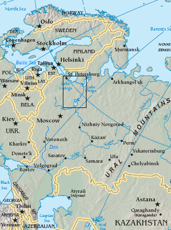
English: Map of the Volga–Baltic Waterway (boxed area).
source map modified with additional labels, box source map modified with additional labels, line drawing, box Original map cropped from https://www.cia.gov/cia/publications/factbook/reference_maps/asia.html |
| 日期 | 2006年8月29號 (original upload date) |
| 來源 | Transferred from en.wikipedia to Commons. |
| 作者 | The original uploader was Jauntymcd at 英文 維基百科. |
協議
This image is in the public domain because it contains materials that originally came from the United States Central Intelligence Agency's World Factbook.
|
 |
This work is based on a work in the public domain. It has been digitally enhanced and/or modified. This derivative work has been (or is hereby) released into the public domain by its author, jauntymcd. This applies worldwide.
In some countries this may not be legally possible; if so: |
Original upload log
The original description page was here. All following user names refer to en.wikipedia.
- 2006-08-29 23:28 Jauntymcd 340×458×8 (214664 bytes) source map modified with additional labels, box source map modified with additional labels, line drawing, box {{PD-retouched-user|jauntymcd}} Original map cropped from https://www.cia.gov/cia/publications/factbook/reference_maps/asia.html {{PD-USGov-CIA-
檔案歷史
撳個日期/時間去睇響嗰個時間出現過嘅檔案。
| 日期/時間 | 縮圖 | 尺寸 | 用戶 | 註解 | |
|---|---|---|---|---|---|
| 現時 | 2007年12月19號 (三) 01:32 | | 340 × 458(210 KB) | Geanixx | {{Information |Description={{en|source map modified with additional labels, box source map modified with additional labels, line drawing, box Original map cropped from https://www.cia.gov/cia/publications/factbook/reference_maps/asia.html}} |Source=Tran |
檔案用途
以下嘅1版用到呢個檔:
全域檔案使用情況
下面嘅維基都用緊呢個檔案:
- da.wikipedia.org嘅使用情況
- en.wikipedia.org嘅使用情況
- eo.wikipedia.org嘅使用情況
- es.wikipedia.org嘅使用情況
- eu.wikipedia.org嘅使用情況
- fa.wikipedia.org嘅使用情況
- he.wikipedia.org嘅使用情況
- it.wikipedia.org嘅使用情況
- ja.wikipedia.org嘅使用情況
- nn.wikipedia.org嘅使用情況
- no.wikipedia.org嘅使用情況
- pl.wikipedia.org嘅使用情況
- sl.wikipedia.org嘅使用情況
- uz.wikipedia.org嘅使用情況
- zh.wikipedia.org嘅使用情況