File:Carte gabon.png
冇更高解像度嘅圖像。
Carte_gabon.png (326 × 349 像素,檔案大細:13 KB ,MIME類型:image/png)
摘要
| 描述 |
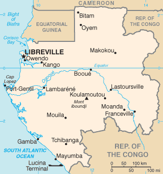
English: Map of Gabon |
| 日期 |
2005年3月27號 (original upload date) 21 August 2008 (Last source update) |
| 來源 | CIA World Factbook |
| 作者 | CIA |
| Other versions |
|


協議
This image is in the public domain because it contains materials that originally came from the United States Central Intelligence Agency's World Factbook.
|
 |
檔案歷史
撳個日期/時間去睇響嗰個時間出現過嘅檔案。
| 日期/時間 | 縮圖 | 尺寸 | 用戶 | 註解 | |
|---|---|---|---|---|---|
| 現時 | 2022年1月24號 (一) 18:42 | | 326 × 349(13 KB) | Lojwe | Cropped 1 % horizontally, 1 % vertically using CropTool with precise mode. |
| 2011年12月3號 (六) 16:00 |  | 329 × 352(13 KB) | Vincent.vaquin | more up to date map with river and more cities | |
| 2006年3月3號 (五) 17:31 |  | 330 × 355(36 KB) | Historicair | Carte du Gabon Carte d'origine : User:Alfio Traduction : ~~~~ {{PD-USGov-CIA-WF}} {{Atelier graphique carte}} Category:Maps of Gabon |
檔案用途
以下嘅1版用到呢個檔:
全域檔案使用情況
下面嘅維基都用緊呢個檔案:
- ar.wikipedia.org嘅使用情況
- ast.wikipedia.org嘅使用情況
- az.wikipedia.org嘅使用情況
- be-tarask.wikipedia.org嘅使用情況
- br.wikipedia.org嘅使用情況
- ca.wikipedia.org嘅使用情況
- cs.wikipedia.org嘅使用情況
- cy.wikipedia.org嘅使用情況
- da.wikipedia.org嘅使用情況
- de.wikipedia.org嘅使用情況
- en.wikipedia.org嘅使用情況
- en.wikisource.org嘅使用情況
- eo.wikipedia.org嘅使用情況
- eu.wikipedia.org嘅使用情況
- fa.wikipedia.org嘅使用情況
- fi.wikipedia.org嘅使用情況
- fi.wikivoyage.org嘅使用情況
- fo.wikipedia.org嘅使用情況
- fr.wikipedia.org嘅使用情況
- gd.wikipedia.org嘅使用情況
- gl.wikipedia.org嘅使用情況
- hr.wikipedia.org嘅使用情況
- hu.wikipedia.org嘅使用情況
- hu.wiktionary.org嘅使用情況
- id.wikipedia.org嘅使用情況
- ilo.wikipedia.org嘅使用情況
- is.wikipedia.org嘅使用情況
- it.wikipedia.org嘅使用情況
睇呢個檔案嘅更多全域使用情況。