File:Frankish Empire 481 to 814-en.svg

呢個「SVG」檔案嘅呢個「PNG」預覽嘅大細:792 × 600 像素。 第啲解像度:317 × 240 像素|634 × 480 像素|1,014 × 768 像素|1,280 × 969 像素|2,560 × 1,939 像素|1,591 × 1,205 像素。
原本檔案 (SVG檔案,表面大細: 1,591 × 1,205 像素,檔案大細:834 KB)
摘要
| 描述 |
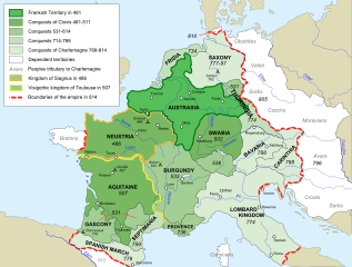
[] Afrikaans: Die veranderende strekking van die Frankiese Ryk van 481 tot 814. Alemannisch: S Frankeriich vo 481 bis 814. Bahasa Indonesia: Peta kebangkitan Kekaisaran Franka, dari tahun 481 hingga 814. Català: Mapa de l'expansió de l'Imperi Franc, de 481 a 814. Deutsch: Karte der Ausdehnung des Fränkischen Reichs 481 bis 814. English: Map of the rise of Frankish Empire, from 481 to 814. Español: Mapa de la expansión del Imperio Franco, entre 481 y 814. Euskara: Frankoen Inperioaren hedapenaren mapa, 481-814 urteen bitartean. Français : Carte de l'expansion de l'empire Franc, entre 481 et 814. Italiano: Carta dell'espansione dell'impero dei Franchi tra il 481 e il 814. Magyar: Frank Birodalom 481-814 Nederlands: Kaart van de opkomst van het Frankische Rijk, van 481 tot 814. Polski: Mapa rozwoju Imperium Franków w latach 481-814 Português: Mapa da expansão do Império Franco, entre 481 e 814. Română: Harta ascensiunii Imperiului franc, 481-814. Svenska: Karantanien i det frankiska riket (år 788 - 843). Ελληνικά: Η Φραγκική Αυτοκρατορία 481-814 Македонски: Карта на подемот на Франкското царство, од 481 до 814 г. Русский: Карта расширения империи франков, между 481 и 814. Українська: Карта розширення імперії Франків в період 481-814 рр. 日本語: カロリング朝の版図。 中文: 墨洛温王朝到加洛林王朝(481—814)的法兰克王国。 العربية : إمبراطوريَّة الفرنجة ما بين عاميّ 481 و814م |
| 日期 | |
| 來源 |
Own work using:
|
| 作者 | Sémhur |
| Other versions |
Derivative works of this file: Frankish Empire 481 to 814-sr.svg
[]
|
| Camera location | | View this and other nearby images on: OpenStreetMap |
|---|

|
This SVG file contains embedded text that can be translated into your language, using any capable SVG editor, text editor or the SVG Translate tool. For more information see: About translating SVG files. |
This W3C-unspecified vector image was created with Inkscape .
協議
I, the copyright holder of this work, hereby publish it under the following licenses:
| Copyleft: This work of art is free; you can redistribute it and/or modify it according to terms of the Free Art License. You will find a specimen of this license on the Copyleft Attitude site as well as on other sites. |
This file is licensed under the Creative Commons Attribution-Share Alike 3.0 Unported, 2.5 Generic, 2.0 Generic and 1.0 Generic license.
- 你可以:
- 去分享 – 複製、發佈同傳播呢個作品
- 再改 – 創作演繹作品
- 要遵照下面嘅條件:
- 署名 – 你一定要畀合適嘅表彰、畀返指向呢個授權條款嘅連結,同埋寫明有無改過嚟。你可以用任何合理方式去做,但唔可以用任何方式暗示授權人認可咗你或者你嘅使用方式。
- 相同方式分享 – 如果你用任何方式改過呢個作品,你必須要用返原本或者相似嘅條款發佈。
你可以揀你想用嘅牌照。
檔案歷史
撳個日期/時間去睇響嗰個時間出現過嘅檔案。
| 日期/時間 | 縮圖 | 尺寸 | 用戶 | 註解 | |
|---|---|---|---|---|---|
| 現時 | 2012年9月5號 (三) 18:10 | | 1,591 × 1,205(834 KB) | Hel-hama | minor corrections |
| 2012年9月5號 (三) 17:35 |  | 1,591 × 1,205(844 KB) | Hel-hama | second attempt to upload file | |
| 2012年9月2號 (日) 19:34 |  | 1,735 × 1,227(331 KB) | Hel-hama | Reverted to version as of 05:50, 7 May 2012 | |
| 2012年9月2號 (日) 19:30 |  | 1,796 × 1,796(973 KB) | Hel-hama | General improvements to map to make it more easy to read. | |
| 2012年5月7號 (一) 05:50 |  | 1,735 × 1,227(331 KB) | Oosh | Fixed discrepancy between colours used in 481 Territory and Legend. Increased the blue channel in 714-768 Conquests for better contrast against 481-511 conquests. -~~~~ | |
| 2007年10月15號 (一) 14:41 |  | 1,735 × 1,227(331 KB) | Sémhur | {{Information |Description=Map of the rise of Frankish Empire, from 481 to 814. |Source=Own work, from Image:Frankish empire.jpg. |Date=2007-10-15 |Author= Sémhur ·<font size="4" color="forestgreen">[[:fr:Special:Emailuser/Sémhur| |
檔案用途
全域檔案使用情況
下面嘅維基都用緊呢個檔案:
- ar.wikipedia.org嘅使用情況
- av.wikipedia.org嘅使用情況
- azb.wikipedia.org嘅使用情況
- az.wikipedia.org嘅使用情況
- bh.wikipedia.org嘅使用情況
- bn.wikipedia.org嘅使用情況
- bs.wikipedia.org嘅使用情況
- ceb.wikipedia.org嘅使用情況
- cs.wikipedia.org嘅使用情況
- da.wikipedia.org嘅使用情況
- en.wikipedia.org嘅使用情況
- Charlemagne
- Europe
- 774
- 481
- History of Burgundy
- History of the European Union
- Carolingian Empire
- Austrasia
- Carantania
- Carolingian dynasty
- List of Frankish kings
- Frankish language
- Charles the Younger
- Portal:European Union
- Kingdom of Soissons
- Benveniste
- Saxon Wars
- History of Western civilization
- List of revolutions and rebellions
- Duchy of Franconia
- User talk:Trasamundo
- Frisian–Frankish wars
- Wikipedia:WikiProject Maps/Conventions/Historical maps
- Duchy of Thuringia
- Succession to the French throne
- User:Kazkaskazkasako/Books/History
- History of Metz
睇呢個檔案嘅更多全域使用情況。