File:Indonesia 2002 CIA map.png
原本檔案 (2,690 × 1,800 像素,檔案大細:2.71 MB ,MIME類型:image/png)
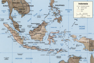
Indonesia.
United States. Central Intelligence Agency.
CREATED/PUBLISHED [Washington, D.C. : Central Intelligence Agency, 2002]
NOTES Relief shown by shading.
"Base 802899AI (C00429) 11-02."
Also issued without shaded relief.
Scale [ca. 1:25,000,000] ; Mercator proj. (E 1040--E 1430/N 170--S 150).
SUBJECTS Indonesia--Maps. Indonesia.
MEDIUM 1 map : col. ; 16 x 23 cm.
CALL NUMBER G8070 2002 .U6
REPOSITORY Library of Congress Geography and Map Division Washington, D.C. 20540-4650 USA
DIGITAL ID g8070 ct000982 http://hdl.loc.gov/loc.gmd/g8070.ct000982
| This image is a work of a Central Intelligence Agency employee, taken or made as part of that person's official duties. As a Work of the United States Government, this image or media is in the public domain in the United States.
|

|
Other versions: Image:Indonesia 2002 CIA map.jpg, File:Indonesia 2002 CIA map-ar.png
檔案歷史
撳個日期/時間去睇響嗰個時間出現過嘅檔案。
| 日期/時間 | 縮圖 | 尺寸 | 用戶 | 註解 | |
|---|---|---|---|---|---|
| 現時 | 2012年11月30號 (五) 16:48 |  | 2,690 × 1,800(2.71 MB) | Ras67 | 0.1 degree ccw rotated, cropped and sharpened from the original |
| 2007年5月27號 (日) 16:39 |  | 2,692 × 1,816(2.41 MB) | Nichalp | compressed map | |
| 2007年5月27號 (日) 16:29 |  | 2,904 × 2,210(7.3 MB) | Nichalp | Indonesia. United States. Central Intelligence Agency. CREATED/PUBLISHED [Washington, D.C. : Central Intelligence Agency, 2002] NOTES Relief shown by shading. "Base 802899AI (C00429) 11-02." Also issued without shaded relief. Scale [ca. 1:25,000,000 |
檔案用途
以下嘅1版用到呢個檔:
全域檔案使用情況
下面嘅維基都用緊呢個檔案:
- als.wikipedia.org嘅使用情況
- ar.wikipedia.org嘅使用情況
- arz.wikipedia.org嘅使用情況
- ban.wikipedia.org嘅使用情況
- ba.wikipedia.org嘅使用情況
- blk.wikipedia.org嘅使用情況
- bs.wikipedia.org嘅使用情況
- bug.wikipedia.org嘅使用情況
- bxr.wikipedia.org嘅使用情況
- ceb.wikipedia.org嘅使用情況
- ch.wikipedia.org嘅使用情況
- crh.wikipedia.org嘅使用情況
- csb.wikipedia.org嘅使用情況
- cs.wikipedia.org嘅使用情況
- cu.wikipedia.org嘅使用情況
- cy.wikipedia.org嘅使用情況
- da.wikipedia.org嘅使用情況
- diq.wikipedia.org嘅使用情況
- dv.wikipedia.org嘅使用情況
- en.wikipedia.org嘅使用情況
- en.wikinews.org嘅使用情況
- es.wikipedia.org嘅使用情況
- fo.wikipedia.org嘅使用情況
- frp.wikipedia.org嘅使用情況
- fr.wikipedia.org嘅使用情況
- gd.wikipedia.org嘅使用情況
- hi.wikibooks.org嘅使用情況
- ht.wikipedia.org嘅使用情況
- ia.wikipedia.org嘅使用情況
- id.wikipedia.org嘅使用情況
- incubator.wikimedia.org嘅使用情況
- it.wikipedia.org嘅使用情況
- iu.wikipedia.org嘅使用情況
- ja.wikipedia.org嘅使用情況
- kaa.wikipedia.org嘅使用情況
- kk.wikipedia.org嘅使用情況
- km.wikipedia.org嘅使用情況
- kn.wikipedia.org嘅使用情況
- kv.wikipedia.org嘅使用情況
睇呢個檔案嘅更多全域使用情況。