File:Maas memel etsch belt.svg

呢個「SVG」檔案嘅呢個「PNG」預覽嘅大細:650 × 600 像素。 第啲解像度:260 × 240 像素|520 × 480 像素|832 × 768 像素|1,109 × 1,024 像素|2,219 × 2,048 像素|1,300 × 1,200 像素。
原本檔案 (SVG檔案,表面大細: 1,300 × 1,200 像素,檔案大細:608 KB)
摘要
Description - Beschreibung
| 描述 |
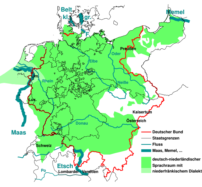
English: The German national anthem Deutschlandlied was written in 1841, giving four water bodies as borders of the German language Sprachraum of the time "Von der Maas bis an die Memel, von der Etsch bis an den Belt". This maps outlines them, and the border of the German Confederation of the time.
Deutsch: "Von der Maas bis an die Memel, von der Etsch bis an den Belt", die 4 "Grenzen" aus dem Deutschlandlied im geographisch-historischen Kontext von 1841:
Die Grenzen wurden der Karte auf der Seite Deutscher Bund entnommen und auf den Zustand 1841 vereinfacht. Die Sprachverteilung wurde stark vereinfacht aus einer Karte der Seite Deutsche Sprache entnommen und gibt den Zustand von 1910 wieder, der sich aber vermutlich nicht so stark von 1841 unterscheidet. Sie soll nur grobe Zusammenhänge zwischen damaliger Sprachverteilung zu den damaligen Grenzen aufzeigen. |
| 日期 | |
| 來源 | like File:Map-DB-Frankfurt.svg from http://www.ieg-maps.uni-mainz.de, and: File:Deutscher Bund.png, File:Historisches deutsches Sprachgebiet.PNG, File:Continental West Germanic languages.png |
| 作者 | Mueck |
| Other versions | |
| SVG genesis |


.svg)
協議
I, the copyright holder of this work, hereby publish it under the following licenses:

|
根據自由軟體基金會發佈嘅無固定段落、封面文字同封底文字GNU自由文件授權條款第1.2或打後嘅版本,你獲授權可以重製、散佈同埋修改爾份文件。授權條款嘅副本喺章節GNU自由文件授權條款。 |
Ĉi tiu dosiero estas disponebla laŭ la permesilo Krea Komunaĵo Atribuite 3.0 Neadaptita.
- 你可以:
- 去分享 – 複製、發佈同傳播呢個作品
- 再改 – 創作演繹作品
- 要遵照下面嘅條件:
- 署名 – 你一定要畀合適嘅表彰、畀返指向呢個授權條款嘅連結,同埋寫明有無改過嚟。你可以用任何合理方式去做,但唔可以用任何方式暗示授權人認可咗你或者你嘅使用方式。
你可以揀你想用嘅牌照。
檔案歷史
撳個日期/時間去睇響嗰個時間出現過嘅檔案。
| 日期/時間 | 縮圖 | 尺寸 | 用戶 | 註解 | |
|---|---|---|---|---|---|
| 現時 | 2023年8月11號 (五) 02:33 | | 1,300 × 1,200(608 KB) | Amlz | Reverted to version as of 13:07, 30 May 2017 (UTC) to correct weird vector artifacts |
| 2017年7月22號 (六) 01:00 |  | 1,301 × 1,201(652 KB) | AKAKIOS | Removed the Dutch speaking area and left only the Dutch/Low Frankish dialects in modern Germany. To add the Netherlands and Flanders to this map is inaccurate, both in its contemporary and historical context. | |
| 2017年5月30號 (二) 13:07 |  | 1,300 × 1,200(608 KB) | Mueck | Reverted to version as of 19:16, 27 January 2011 (UTC) Indeed: Correctomundo~commonswiki produced bad quality, autotraced (or some other bad technic ...) and content: the "historic continuum" is just the interesting thing in this map ... | |
| 2014年8月12號 (二) 00:03 |  | 1,301 × 1,201(652 KB) | Correctomundo~commonswiki | Fixed. | |
| 2014年8月11號 (一) 23:55 |  | 1,300 × 1,200(608 KB) | Correctomundo~commonswiki | Same problem. | |
| 2014年8月11號 (一) 23:55 |  | 1,300 × 1,200(608 KB) | Correctomundo~commonswiki | Same problem. | |
| 2014年8月11號 (一) 23:54 |  | 1,625 × 1,500(241 KB) | Correctomundo~commonswiki | Color correction. | |
| 2014年8月11號 (一) 23:53 |  | 1,300 × 1,200(608 KB) | Correctomundo~commonswiki | something went wrong with the colours | |
| 2014年8月11號 (一) 23:53 |  | 1,625 × 1,500(57 KB) | Correctomundo~commonswiki | Removed Dutch and Standard Dutch influenced dialects. These are not German dialects, even though there historically was a continuum. | |
| 2011年1月27號 (四) 19:16 |  | 1,300 × 1,200(608 KB) | NordNordWest | c |
檔案用途
以下嘅1版用到呢個檔:
全域檔案使用情況
下面嘅維基都用緊呢個檔案:
- az.wikipedia.org嘅使用情況
- cs.wikipedia.org嘅使用情況
- de.wikipedia.org嘅使用情況
- en.wikipedia.org嘅使用情況
- fi.wikipedia.org嘅使用情況
- fr.wikipedia.org嘅使用情況
- ka.wikipedia.org嘅使用情況
- ko.wikipedia.org嘅使用情況
- sr.wikipedia.org嘅使用情況
- zh.wikipedia.org嘅使用情況