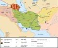
File:Map Iran 1900-en.png

預覽大細:721 × 599 像素。 第啲解像度:289 × 240 像素|578 × 480 像素|924 × 768 像素|1,096 × 911 像素。
原本檔案 (1,096 × 911 像素,檔案大細:352 KB ,MIME類型:image/png)
檔案歷史
撳個日期/時間去睇響嗰個時間出現過嘅檔案。
| 日期/時間 | 縮圖 | 尺寸 | 用戶 | 註解 | |
|---|---|---|---|---|---|
| 現時 | 2017年8月6號 (日) 17:40 |  | 1,096 × 911(352 KB) | Oganesson007 | Added Kingdom of Kartli-Kakheti, deleted modern day Turkmenistan, which was never under Qajar's control. |
| 2015年7月20號 (一) 15:18 |  | 1,096 × 911(353 KB) | LouisAragon | When people say your previous map that showed the same is wrong, don't sneakily change it on an already existing map to push your PoV. Cais-Soas is not a source. | |
| 2015年7月19號 (日) 19:46 |  | 1,096 × 910(327 KB) | History of Persia | The Qajars had control of Herat before 1857.EVIDENCE: Treaty of Paris (1857) (wikipedia article). See the reference list for that article. Also see this map of Persia from 1808: http://www.cais-soas.com/CAIS/Images2/Maps/breaku1.jpg | |
| 2015年7月19號 (日) 19:42 |  | 1,096 × 910(327 KB) | History of Persia | The Qajars had control of Herat before 1857. EVIDENCE: Treaty of Paris (1857) (wikipedia article). Also see the reference list for that article. Also see this map of Persia from 1808: https://upload.wikimedia.org/wikipedia/commons/thumb/f/f9/Persia1808... | |
| 2013年6月24號 (一) 17:29 |  | 1,096 × 911(353 KB) | HistoryofIran | Fixed the horrible non-accurate borders and fixed territorial losses. | |
| 2013年4月28號 (日) 15:53 |  | 1,096 × 911(356 KB) | HistoryofIran | ||
| 2006年9月24號 (日) 21:35 |  | 1,096 × 911(358 KB) | Fabienkhan | uploaded updated version | |
| 2006年9月24號 (日) 21:32 |  | 1,098 × 927(367 KB) | Fabienkhan | ||
| 2006年9月24號 (日) 20:58 |  | 1,098 × 924(384 KB) | Fabienkhan | <div style="height:8px; border:1px solid #8898BF; -moz-border-radius-topleft:8px; -moz-border-radius-topright:8px; background:#C8D8FF; font-size:1px;"> </div> <div style="margin-bottom:1.5em; border:1px solid #8898BF; border-top:0; padding:5px; background |
檔案用途
以下嘅1版用到呢個檔:
全域檔案使用情況
下面嘅維基都用緊呢個檔案:
- ar.wikipedia.org嘅使用情況
- ast.wikipedia.org嘅使用情況
- azb.wikipedia.org嘅使用情況
- az.wikipedia.org嘅使用情況
- ba.wikipedia.org嘅使用情況
- be.wikipedia.org嘅使用情況
- bg.wikipedia.org嘅使用情況
- bo.wikipedia.org嘅使用情況
- ca.wikipedia.org嘅使用情況
- ckb.wikipedia.org嘅使用情況
- cs.wikipedia.org嘅使用情況
- de.wikipedia.org嘅使用情況
- el.wikipedia.org嘅使用情況
- en.wikipedia.org嘅使用情況
- Iran
- History of Iran
- Great Game
- Sphere of influence
- Anglo-Russian Convention
- Military history of Iran
- Territorial evolution of Russia
- History of Azerbaijan
- Iranian nationalism
- Portal:Azerbaijan
- Russia–United Kingdom relations
- Wikipedia:Graphics Lab/Images to improve/Archive/Apr 2008
- Qajar Iran
- User:Chickstarr404/Gather lists/14627 – Personal History - Desert Gardens by Vincent Sheehan
- User:Joelton Ivson/Gather lists/24351 – Geórgia
- User:Joelton Ivson/Gather lists/24359 – Os Persas
- User:Falcaorib
- User:Thecatcherintherye/Sandbox
- Turkoman (ethnonym)
- Erdoğan Iran poem controversy
- User talk:A Contemporary Nomad
- es.wikipedia.org嘅使用情況
睇呢個檔案嘅更多全域使用情況。

