Map_Kumano_Kodo_(ja).png(640 × 480 像素,檔案大細:72 KB ,MIME類型:image/png

摘要

描述
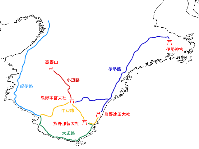
日本語: 熊野古道の地図 ja::画像:JpLargeMap_Kinki.pngから作成。
English: Map of the old roads of Kumano, medieval pilgrimage routes. Red icons are shrines and temples that the roads begin and terminate at.
日期 2004年9月23號 (original upload date)
來源 Transferred from ja.wikipedia to Commons.
作者 The original uploader was Yosemite at 日文 維基百科.
Other versions

協議

Public domain This work has been released into the public domain by its author, Yosemite. This applies worldwide.

In some countries this may not be legally possible; if so:
Yosemite grants anyone the right to use this work for any purpose, without any conditions, unless such conditions are required by law.

Original upload log

The original description page was here. All following user names refer to ja.wikipedia.
  • 2004-09-23 08:14 Yosemite 640×480×8 (73413 bytes) 熊野古道の地図

Captions

Add a one-line explanation of what this file represents

Items portrayed in this file

圖中顯示嘅係

23 9 2004

檔案歷史

撳個日期/時間去睇響嗰個時間出現過嘅檔案。

日期/時間縮圖尺寸用戶註解
現時2008年5月7號 (三) 03:39響2008年5月7號 (三) 03:39嘅縮圖版本640 × 480(72 KB)File Upload Bot (Magnus Manske) {{BotMoveToCommons|ja.wikipedia}} {{Information |Description={{ja|熊野古道の地図 ja::画像:JpLargeMap_Kinki.pngから作成。}} |Source=Transferred from [http://ja.wikipedia.org ja.wikipedia] |Date

以下嘅1版用到呢個檔:

全域檔案使用情況

下面嘅維基都用緊呢個檔案: