File:Pearl River Delta Area.png

預覽大細:750 × 600 像素。 第啲解像度:300 × 240 像素|600 × 480 像素|1,000 × 800 像素。
原本檔案 (1,000 × 800 像素,檔案大細:182 KB ,MIME類型:image/png)
摘要
| 描述 |
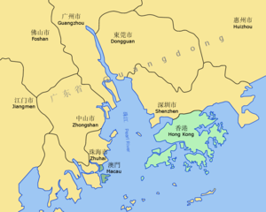
Pearl River Delta — eastern portion, in Guangdong Province.
Map drawn in October 2007 using various sources, mainly : |
| 日期 | |
| 來源 | 自己作品 |
| 作者 | Croquant |
協議
我,呢份作品嘅作者,決定用以下許可發佈呢件作品:
Ĉi tiu dosiero estas disponebla laŭ la permesilo Krea Komunaĵo Atribuite 3.0 Neadaptita.
- 你可以:
- 去分享 – 複製、發佈同傳播呢個作品
- 再改 – 創作演繹作品
- 要遵照下面嘅條件:
- 署名 – 你一定要畀合適嘅表彰、畀返指向呢個授權條款嘅連結,同埋寫明有無改過嚟。你可以用任何合理方式去做,但唔可以用任何方式暗示授權人認可咗你或者你嘅使用方式。
檔案歷史
撳個日期/時間去睇響嗰個時間出現過嘅檔案。
| 日期/時間 | 縮圖 | 尺寸 | 用戶 | 註解 | |
|---|---|---|---|---|---|
| 現時 | 2007年10月11號 (四) 19:38 | | 1,000 × 800(182 KB) | Croquant | lighter color for Province name |
| 2007年10月11號 (四) 19:05 |  | 1,000 × 800(186 KB) | Croquant | Pearl River Chinese name updated | |
| 2007年10月11號 (四) 18:57 |  | 1,000 × 800(185 KB) | Croquant | Province and River names | |
| 2007年10月11號 (四) 16:54 |  | 1,000 × 800(167 KB) | Croquant | edition Jiangmen Prefecture | |
| 2007年10月11號 (四) 15:44 |  | 1,000 × 800(152 KB) | Croquant | == Summary == {{Information |Description=Pearl River Delta area, showing boundaries of the Special Administrative Regions of Honk Kong and Macau, and the bordering Guangdong Prefectures Map drawn in october 2007 using various sources, mainly : * [http:// |
檔案用途
以下嘅1版用到呢個檔:
全域檔案使用情況
下面嘅維基都用緊呢個檔案:
- af.wikipedia.org嘅使用情況
- ar.wikipedia.org嘅使用情況
- ast.wikipedia.org嘅使用情況
- az.wikipedia.org嘅使用情況
- ba.wikipedia.org嘅使用情況
- bn.wikipedia.org嘅使用情況
- ca.wikipedia.org嘅使用情況
- da.wikipedia.org嘅使用情況
- de.wikipedia.org嘅使用情況
- en.wikipedia.org嘅使用情況
- Geography of Hong Kong
- User talk:Badagnani/Archive 10
- Talk:Hong Kong/Archive 8
- Wikipedia:WikiProject China/Pearl River Delta workgroup
- Template:User Pearl River Delta WG
- Wikipedia:Graphics Lab/Map workshop/Archive/Sep 2018
- Wikipedia:Userboxes/WikiProjects/alphabetical/22
- Wikipedia:Userboxes/WikiProjects/Regional/08
- en.wikivoyage.org嘅使用情況
- eo.wikipedia.org嘅使用情況
- es.wikipedia.org嘅使用情況
- et.wikipedia.org嘅使用情況
- eu.wikipedia.org嘅使用情況
- fr.wikipedia.org嘅使用情況
- fr.wiktionary.org嘅使用情況
睇呢個檔案嘅更多全域使用情況。