File:Russia-CIA WFB Map--Tunguska.png
冇更高解像度嘅圖像。
Russia-CIA_WFB_Map--Tunguska.png (631 × 321 像素,檔案大細:27 KB ,MIME類型:image/png)

|
This map image could be recreated using vector graphics as an SVG file. This has several advantages; see Commons:Media for cleanup for more information. If an SVG form of this image is already available, please upload it. After uploading an SVG, replace this template with {{vector version available|new image name.svg}}.
|
| 描述 |
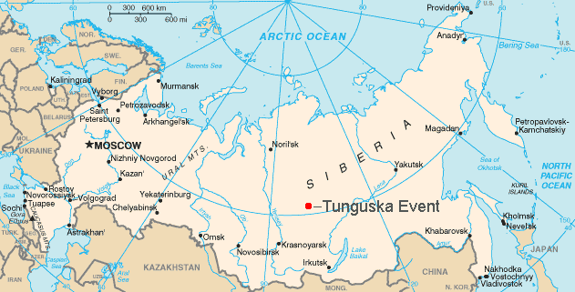
English: Map showing the approximate location of the Tunguska event of 1908. |
||||||||
| 來源 | CIA | ||||||||
| 作者 |
English: This is a hacked version of the public domain map Russia-CIA WFB Map.png.
User:Bobby D. Bryant made the modifications and uploaded it under the GFDL on May 21, 2005. |
||||||||
| 許可 (重用呢個檔案) |
|

檔案歷史
撳個日期/時間去睇響嗰個時間出現過嘅檔案。
| 日期/時間 | 縮圖 | 尺寸 | 用戶 | 註解 | |
|---|---|---|---|---|---|
| 現時 | 2012年6月30號 (六) 18:41 | | 631 × 321(27 KB) | Ras67 | cropped |
| 2006年9月11號 (一) 16:09 |  | 634 × 323(31 KB) | Amic~commonswiki | {{Information |Description=Map showing the approximate location of the Tunguska event of 1908. |Source=This is a hacked version of the public domain map Russia-CIA WFB Map.png. [[w:User:Bobby D. Bryant|User:Bobby D. Bryan | |
| 2005年5月21號 (六) 15:35 |  | 634 × 323(29 KB) | Bobby D. Bryant~commonswiki | {{CIA-map}} |
檔案用途
以下嘅1版用到呢個檔:
全域檔案使用情況
下面嘅維基都用緊呢個檔案:
- af.wikipedia.org嘅使用情況
- ast.wikipedia.org嘅使用情況
- bcl.wikipedia.org嘅使用情況
- be.wikipedia.org嘅使用情況
- bg.wikipedia.org嘅使用情況
- bs.wikipedia.org嘅使用情況
- cs.wikipedia.org嘅使用情況
- da.wikipedia.org嘅使用情況
- el.wikipedia.org嘅使用情況
- en.wikipedia.org嘅使用情況
- eo.wikipedia.org嘅使用情況
- es.wikipedia.org嘅使用情況
- et.wikipedia.org嘅使用情況
- fa.wikipedia.org嘅使用情況
- fi.wikipedia.org嘅使用情況
- gl.wikipedia.org嘅使用情況
- hi.wikipedia.org嘅使用情況
- hu.wikipedia.org嘅使用情況
- ja.wikipedia.org嘅使用情況
- kn.wikipedia.org嘅使用情況
- li.wikipedia.org嘅使用情況
- lt.wikipedia.org嘅使用情況
- ml.wikipedia.org嘅使用情況
- ms.wikipedia.org嘅使用情況
- nn.wikipedia.org嘅使用情況
- no.wikipedia.org嘅使用情況
- pl.wikipedia.org嘅使用情況
- pt.wikipedia.org嘅使用情況
- ro.wikipedia.org嘅使用情況
- sco.wikipedia.org嘅使用情況
- sh.wikipedia.org嘅使用情況
- simple.wikipedia.org嘅使用情況
- si.wikipedia.org嘅使用情況
- sk.wikipedia.org嘅使用情況
- sv.wikipedia.org嘅使用情況
- ta.wikipedia.org嘅使用情況
- uk.wikipedia.org嘅使用情況
- uz.wikipedia.org嘅使用情況
- vi.wikipedia.org嘅使用情況
- war.wikipedia.org嘅使用情況