File:15-07-14-Yucatan-Ölfelder-RalfR-WMA 0481.jpg
原本檔案 (2,719 × 1,815 像素,檔案大細:1.49 MB ,MIME類型:image/jpeg)
摘要
| 描述 |
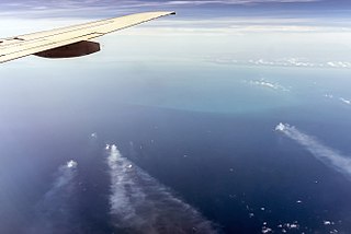
Deutsch: Cantarell, Erdölfeld im Golf von Campeche vor Yucatan, Mexico. Foto aus 11 km Höhe und 40 km Entfernung, am Horizont Laguna de Terminos (150 km entfernt)
English: Cantarell Field, supergiant oil field in Yucatan, Mexico. Photo in 11 km height and 40 km distance; at the horizon Laguna de Terminos (distance 150 km) |
|||||||||||||||||||||||||
| 日期 | ||||||||||||||||||||||||||
| 來源 | 自己作品 | |||||||||||||||||||||||||
| 作者 |
|
|||||||||||||||||||||||||
| 許可 (重用呢個檔案) |
|
|||||||||||||||||||||||||

協議

|
Permission is granted to copy, distribute and/or modify this document under the terms of the GNU Free Documentation License, Version 1.2 only as published by the Free Software Foundation; with no Invariant Sections, no Front-Cover Texts, and no Back-Cover Texts. A copy of the license is included in the section entitled GNU Free Documentation License. | 1.2 only |
This image has been assessed using the Quality image guidelines and is considered a Quality image.
|

|
This image has been assessed under the valued image criteria and is considered the most valued image on Commons within the scope: Cantarell. You can see its nomination here. |
|
|
This image has been assessed under the valued image criteria and is considered the most valued image on Commons within the scope: Cantarell. You can see its nomination here. |
檔案歷史
撳個日期/時間去睇響嗰個時間出現過嘅檔案。
| 日期/時間 | 縮圖 | 尺寸 | 用戶 | 註解 | |
|---|---|---|---|---|---|
| 現時 | 2015年9月9號 (三) 17:05 |  | 2,719 × 1,815(1.49 MB) | Ralf Roletschek |
檔案用途
以下嘅1版用到呢個檔:
全域檔案使用情況
下面嘅維基都用緊呢個檔案:
- ar.wikipedia.org嘅使用情況
- ast.wikipedia.org嘅使用情況
- azb.wikipedia.org嘅使用情況
- az.wikipedia.org嘅使用情況
- be-tarask.wikipedia.org嘅使用情況
- br.wikipedia.org嘅使用情況
- bs.wikipedia.org嘅使用情況
- ca.wikipedia.org嘅使用情況
- ce.wikipedia.org嘅使用情況
- ckb.wikipedia.org嘅使用情況
- cs.wikipedia.org嘅使用情況
- cv.wikipedia.org嘅使用情況
- cy.wikipedia.org嘅使用情況
- da.wikipedia.org嘅使用情況
- de.wikipedia.org嘅使用情況
- el.wikipedia.org嘅使用情況
- en.wikipedia.org嘅使用情況
- eo.wikipedia.org嘅使用情況
- es.wikipedia.org嘅使用情況
- et.wikipedia.org嘅使用情況
- eu.wikipedia.org嘅使用情況
- fi.wikipedia.org嘅使用情況
- fo.wikipedia.org嘅使用情況
- fy.wikipedia.org嘅使用情況
- gl.wikipedia.org嘅使用情況
- he.wikipedia.org嘅使用情況
- hi.wikipedia.org嘅使用情況
- hu.wikipedia.org嘅使用情況
- id.wikipedia.org嘅使用情況
- ie.wikipedia.org嘅使用情況
- ilo.wikipedia.org嘅使用情況
- it.wikipedia.org嘅使用情況
睇呢個檔案嘅更多全域使用情況。