File:2006 North Korean nuclear test.png
冇更高解像度嘅圖像。
2006_North_Korean_nuclear_test.png (369 × 465 像素,檔案大細:19 KB ,MIME類型:image/png)
摘要
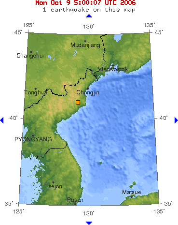
English: 2006 North Korean nuclear test
中文:黃點是2006年北韓核子試爆的地點
Bân-lâm-gú:N̂g-tiám sī 2006-nî Pak-hân hu̍t-tsú tshì-po̍k ê tē-tiám
Made by USGS.
Several modifications (by Ysangkok):
- Cropped
- Added transparency
- Optimized with OptiPNG
Source: USGS's Earthquake department
協議
This image is in the public domain in the United States because it only contains materials that originally came from the United States Geological Survey, an agency of the United States Department of the Interior. For more information, see the official USGS copyright policy.
|
檔案歷史
撳個日期/時間去睇響嗰個時間出現過嘅檔案。
| 日期/時間 | 縮圖 | 尺寸 | 用戶 | 註解 | |
|---|---|---|---|---|---|
| 現時 | 2007年1月28號 (日) 14:29 | | 369 × 465(19 KB) | Tene~commonswiki | Optimised (no filter, 2048 block split, randomised tables) |
| 2006年11月12號 (日) 18:06 |  | 369 × 465(21 KB) | Ysangkok | ||
| 2006年10月9號 (一) 16:51 |  | 369 × 465(44 KB) | Ysangkok | ||
| 2006年10月9號 (一) 05:06 |  | 439 × 499(38 KB) | Neutrality | [http://earthquake.usgs.gov/eqcenter/recenteqsww/Maps/10/130_40.php] |
檔案用途
以下嘅1版用到呢個檔:
全域檔案使用情況
下面嘅維基都用緊呢個檔案:
- cs.wikipedia.org嘅使用情況
- en.wikipedia.org嘅使用情況
- en.wikinews.org嘅使用情況
- es.wikipedia.org嘅使用情況
- fi.wikipedia.org嘅使用情況
- fr.wikipedia.org嘅使用情況
- fr.wikinews.org嘅使用情況
- it.wikinews.org嘅使用情況
- ja.wikipedia.org嘅使用情況
- ko.wikipedia.org嘅使用情況
- nl.wikipedia.org嘅使用情況
- pt.wikipedia.org嘅使用情況
- ro.wikipedia.org嘅使用情況
- ru.wikipedia.org嘅使用情況
- ru.wikinews.org嘅使用情況
- simple.wikipedia.org嘅使用情況
- sv.wikipedia.org嘅使用情況
- uk.wikipedia.org嘅使用情況
- uz.wikipedia.org嘅使用情況
- zh.wikipedia.org嘅使用情況