File:5 Boroughs Labels New York City Map.svg

呢個「SVG」檔案嘅呢個「PNG」預覽嘅大細:606 × 599 像素。 第啲解像度:243 × 240 像素|485 × 480 像素|777 × 768 像素|1,035 × 1,024 像素|2,071 × 2,048 像素|2,000 × 1,978 像素。
原本檔案 (SVG檔案,表面大細: 2,000 × 1,978 像素,檔案大細:138 KB)
摘要
| 描述 |
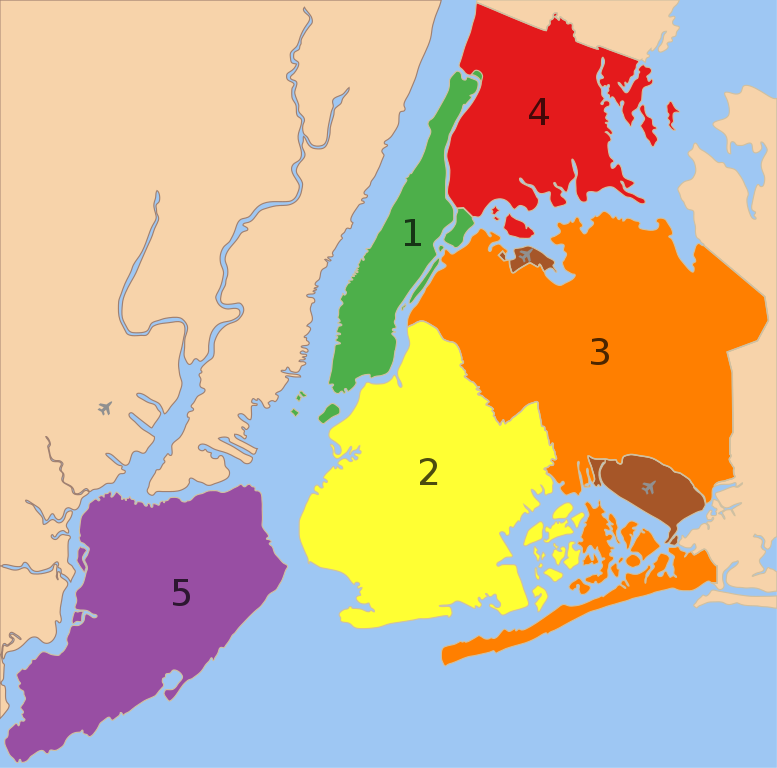
A map showing the five boroughs of New York City, as well as airports. 1. Manhattan
2. Brooklyn
3. Queens
4. Bronx
5. Staten Island
Airports: North East: LGA; South East: JFK; West: EWR |
| 日期 | |
| 來源 |
 |
| 作者 |
|
| Other versions |
 |
協議
| This work has been released into the public domain by its author, Nafsadh. This applies worldwide. In some countries this may not be legally possible; if so: |
檔案歷史
撳個日期/時間去睇響嗰個時間出現過嘅檔案。
| 日期/時間 | 縮圖 | 尺寸 | 用戶 | 註解 | |
|---|---|---|---|---|---|
| 現時 | 2023年2月9號 (四) 22:57 | | 2,000 × 1,978(138 KB) | Nafsadh | Reverted to version as of 18:55, 26 October 2014 (UTC) Intention to not add English label to the svg itself was to keep it mostly language independent and not having to be subject to svg text rendering issues. |
| 2020年1月18號 (六) 08:18 |  | 2,000 × 1,978(150 KB) | Mccbala | Added captions to all 5 boroughs and 2 airports. | |
| 2014年10月26號 (日) 18:55 |  | 2,000 × 1,978(138 KB) | Nafsadh | Cleanup SVG | |
| 2014年10月26號 (日) 10:07 |  | 2,000 × 1,978(138 KB) | Nafsadh | {{Information |Description ={{en|1=5 boroughs}} |Source =File:5_Boroughs_Labels_New_York_City_Map_Julius_Schorzman.png |Author =Julius Schorzman |Date = |Permission = |other_versions = }} |
檔案用途
以下嘅1版用到呢個檔:
全域檔案使用情況
下面嘅維基都用緊呢個檔案:
- arz.wikipedia.org嘅使用情況
- az.wikipedia.org嘅使用情況
- bn.wikipedia.org嘅使用情況
- br.wikipedia.org嘅使用情況
- bs.wikipedia.org嘅使用情況
- cs.wikipedia.org嘅使用情況
- de.wikipedia.org嘅使用情況
- eml.wikipedia.org嘅使用情況
- en.wikipedia.org嘅使用情況
- Municipality
- Administrative divisions of New York (state)
- New York City
- Demographics of New York City
- Boroughs of New York City
- Neighborhoods in New York City
- User:Nafsadh
- User:Nafsadh/Gallery
- User:Saurabh Mittra/Gather lists/18958 – Saurabh's Articles Collection
- User:Andrewa/New York (overview)
- List of African American newspapers in New York
- User:DoctorShmullus/sandbox2
- User:Chronus/sandbox
- en.wikiquote.org嘅使用情況
- fa.wikipedia.org嘅使用情況
- fr.wikipedia.org嘅使用情況
- glk.wikipedia.org嘅使用情況
- hy.wikipedia.org嘅使用情況
- it.wikipedia.org嘅使用情況
- ku.wikipedia.org嘅使用情況
- la.wikipedia.org嘅使用情況
- lfn.wikipedia.org嘅使用情況
- lld.wikipedia.org嘅使用情況
- no.wikipedia.org嘅使用情況
- nso.wikipedia.org嘅使用情況
- oc.wikipedia.org嘅使用情況
- pt.wikipedia.org嘅使用情況
睇呢個檔案嘅更多全域使用情況。