File:Aerial view of city of Oakland 1.jpg

原本檔案 (3,264 × 2,448 像素,檔案大細:6.37 MB ,MIME類型:image/jpeg)
摘要
| 描述 |
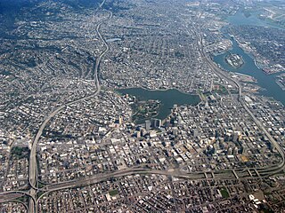
English: Aerial view of city of Oakland, California. Lakeside Park, Lake Merritt in center, Laney College to the right of that, Downtown Oakland right below the lake, Interstate 580 on left, Interstate 980 on bottom, Oakland Inner Harbor Channel and Government Island in upper right. |
| 日期 | |
| 來源 | 自己作品 |
| 作者 | Dcoetzee |
| Camera location | | View this and other nearby images on: OpenStreetMap |
|---|
協議
| I, the copyright holder of this work, release this work into the public domain. This applies worldwide. In some countries this may not be legally possible; if so: I grant anyone the right to use this work for any purpose, without any conditions, unless such conditions are required by law. |
檔案歷史
撳個日期/時間去睇響嗰個時間出現過嘅檔案。
| 日期/時間 | 縮圖 | 尺寸 | 用戶 | 註解 | |
|---|---|---|---|---|---|
| 現時 | 2009年6月4號 (四) 06:59 | | 3,264 × 2,448(6.37 MB) | Dcoetzee | {{Information |Description={{en|1=Aerial view of city of Oakland, California. Lakeside Park, Lake Merritt in center, Laney College to the right of that, Downtown Oakland right below the lake, Interstate 580 on left, Interstate 980 on bottom, Oakland Inner |
檔案用途
以下嘅1版用到呢個檔:
全域檔案使用情況
下面嘅維基都用緊呢個檔案:
- bg.wikipedia.org嘅使用情況
- bm.wikipedia.org嘅使用情況
- en.wikipedia.org嘅使用情況
- fr.wikipedia.org嘅使用情況
- ku.wikipedia.org嘅使用情況
- pa.wikipedia.org嘅使用情況
- pl.wikipedia.org嘅使用情況
- pnb.wikipedia.org嘅使用情況
- ro.wikipedia.org嘅使用情況
- so.wikipedia.org嘅使用情況
- zh.wikipedia.org嘅使用情況