File:Benrather und Speyerer Linie.png
預覽大細:614 × 599 像素。 第啲解像度:246 × 240 像素|492 × 480 像素|787 × 768 像素|1,158 × 1,130 像素。
原本檔案 (1,158 × 1,130 像素,檔案大細:1,011 KB ,MIME類型:image/png)
摘要
| 描述 |
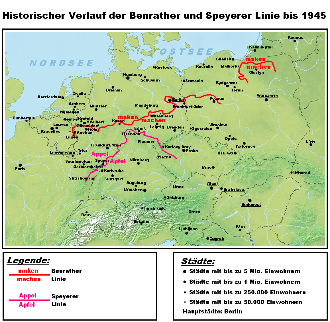
Deutsch: Darstellungskarte des historischen Verlaufes der Benrather und der Speyerer Linie als Trenngrenze zwischen Nieder- und Mitteldeutsch. Die hochdeutschen Sprachinseln nördlich der Benrather Linie werden nicht dargestellt, da es sich hierbei nicht um das Ergebnis einer Lautverschiebung, sondern um spätere Siedlungsbewegungen von Süden nach Norden handelt. Es wurde auch bewusst auf die Darstellung jeglicher Sprachgrenzen verzichtet. English: Map showing the historic position of the isoglosses known as the Speyer and the Benrath line, dividing lower from middle German dialects. Enclaves of high German north of the Benrath line are not displayed, since they are not the effect of a sound shift but result from later south to north migration. Dialect family divisions have also been omitted on purpose. |
| 日期 | |
| 來源 | 自己作品 |
| 作者 | Hardcore-Mike |
協議
我,呢份作品嘅作者,決定用以下許可發佈呢件作品:
呢個檔案用共享創意 姓名標示-非商業性-相同方式分享3.0 未本地化版本條款授權。
- 你可以:
- 去分享 – 複製、發佈同傳播呢個作品
- 再改 – 創作演繹作品
- 要遵照下面嘅條件:
- 署名 – 你一定要畀合適嘅表彰、畀返指向呢個授權條款嘅連結,同埋寫明有無改過嚟。你可以用任何合理方式去做,但唔可以用任何方式暗示授權人認可咗你或者你嘅使用方式。
- 相同方式分享 – 如果你用任何方式改過呢個作品,你必須要用返原本或者相似嘅條款發佈。
檔案歷史
撳個日期/時間去睇響嗰個時間出現過嘅檔案。
| 日期/時間 | 縮圖 | 尺寸 | 用戶 | 註解 | |
|---|---|---|---|---|---|
| 現時 | 2012年5月20號 (日) 11:06 | | 1,158 × 1,130(1,011 KB) | Hans Erren | classic pastel map colours |
| 2010年10月17號 (日) 00:39 |  | 1,158 × 1,130(1.24 MB) | MicBy67 | Kleinigkeiten | |
| 2010年10月15號 (五) 23:38 |  | 1,158 × 1,130(1.23 MB) | MicBy67 | Komplett überarbeitet. Andere Farben und andere Legende, damit man alles besser sehen kann | |
| 2010年10月13號 (三) 16:40 |  | 1,122 × 752(582 KB) | MicBy67 | Isoglosse im ehemaligen Ostpreußen überarbeitet, blassere Isoglossenfarben und dunklerer Hintergrund | |
| 2010年10月10號 (日) 19:31 |  | 1,122 × 752(641 KB) | MicBy67 | Karte verkleinert, Städte hinzugefügt und Benrather Linie bearbeitet | |
| 2010年10月8號 (五) 20:52 |  | 2,805 × 1,880(4.64 MB) | MicBy67 | Legende berichtigt | |
| 2010年10月8號 (五) 20:37 |  | 2,805 × 1,880(5.1 MB) | MicBy67 | Berichtigung der Isoglossen nach Wenker. Isoglossen nun durchgezogene Linien und Grenzen rot | |
| 2010年10月6號 (三) 00:09 |  | 2,805 × 1,880(3.7 MB) | MicBy67 | ||
| 2010年10月4號 (一) 13:28 |  | 3,366 × 2,256(6.29 MB) | MicBy67 | ||
| 2010年10月4號 (一) 08:54 |  | 2,244 × 1,504(3 MB) | MicBy67 |
檔案用途
全域檔案使用情況
下面嘅維基都用緊呢個檔案:
- af.wikipedia.org嘅使用情況
- als.wikipedia.org嘅使用情況
- an.wikipedia.org嘅使用情況
- be-tarask.wikipedia.org嘅使用情況
- be.wikipedia.org嘅使用情況
- br.wikipedia.org嘅使用情況
- ca.wikipedia.org嘅使用情況
- cs.wikipedia.org嘅使用情況
- da.wikipedia.org嘅使用情況
- de.wikipedia.org嘅使用情況
- en.wikipedia.org嘅使用情況
- es.wikipedia.org嘅使用情況
- eu.wikipedia.org嘅使用情況
- fr.wikipedia.org嘅使用情況
- hr.wikipedia.org嘅使用情況
- id.wikipedia.org嘅使用情況
- it.wikipedia.org嘅使用情況
- ja.wikipedia.org嘅使用情況
- ksh.wikipedia.org嘅使用情況
- la.wikipedia.org嘅使用情況
- li.wikipedia.org嘅使用情況
- nds-nl.wikipedia.org嘅使用情況
- nds.wikipedia.org嘅使用情況
- nl.wikipedia.org嘅使用情況
- no.wikipedia.org嘅使用情況
- pdc.wikipedia.org嘅使用情況
- pl.wikipedia.org嘅使用情況
- ru.wikipedia.org嘅使用情況
睇呢個檔案嘅更多全域使用情況。