File:BeringSt-close-VE.jpg

預覽大細:800 × 501 像素。 第啲解像度:320 × 200 像素|640 × 401 像素|1,043 × 653 像素。
原本檔案 (1,043 × 653 像素,檔案大細:112 KB ,MIME類型:image/jpeg)
| 描述 |
|
| 來源 | original from http://www.visibleearth.nasa.gov/cgi-bin/viewrecord?7049 |
| 作者 | NASA |
| 許可 (重用呢個檔案) |
PD-USGov-NASA |
| This file is in the public domain in the United States because it was solely created by NASA. NASA copyright policy states that "NASA material is not protected by copyright unless noted". (See Template:PD-USGov, NASA copyright policy page or JPL Image Use Policy.) | ||
 |
Warnings:
|
| Annotations | This image is annotated: View the annotations at Commons |
檔案歷史
撳個日期/時間去睇響嗰個時間出現過嘅檔案。
| 日期/時間 | 縮圖 | 尺寸 | 用戶 | 註解 | |
|---|---|---|---|---|---|
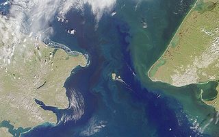
| 現時 | 2005年4月6號 (三) 15:16 | | 1,043 × 653(112 KB) | Laurens~commonswiki | Bering strait NASA image, MISR sattelite |
檔案用途
以下嘅1版用到呢個檔:
全域檔案使用情況
下面嘅維基都用緊呢個檔案:
- af.wikipedia.org嘅使用情況
- als.wikipedia.org嘅使用情況
- ar.wikipedia.org嘅使用情況
- ary.wikipedia.org嘅使用情況
- ast.wikipedia.org嘅使用情況
- az.wikipedia.org嘅使用情況
- ba.wikipedia.org嘅使用情況
- be-tarask.wikipedia.org嘅使用情況
- be.wikipedia.org嘅使用情況
- bg.wikipedia.org嘅使用情況
- bn.wikipedia.org嘅使用情況
- bs.wikipedia.org嘅使用情況
- ckb.wikipedia.org嘅使用情況
- cs.wikipedia.org嘅使用情況
- cv.wikipedia.org嘅使用情況
- da.wikipedia.org嘅使用情況
- de.wikipedia.org嘅使用情況
- el.wikipedia.org嘅使用情況
- en.wikipedia.org嘅使用情況
- en.wiktionary.org嘅使用情況
- eo.wikipedia.org嘅使用情況
- es.wikipedia.org嘅使用情況
- et.wikipedia.org嘅使用情況
睇呢個檔案嘅更多全域使用情況。