File:Champ-de-Mars, Paris - OSM 2020.svg

呢個「SVG」檔案嘅呢個「PNG」預覽嘅大細:800 × 329 像素。 第啲解像度:320 × 132 像素|640 × 263 像素|1,024 × 421 像素|1,280 × 527 像素|2,560 × 1,053 像素|1,920 × 790 像素。
原本檔案 (SVG檔案,表面大細: 1,920 × 790 像素,檔案大細:462 KB)
摘要
| 標題 |
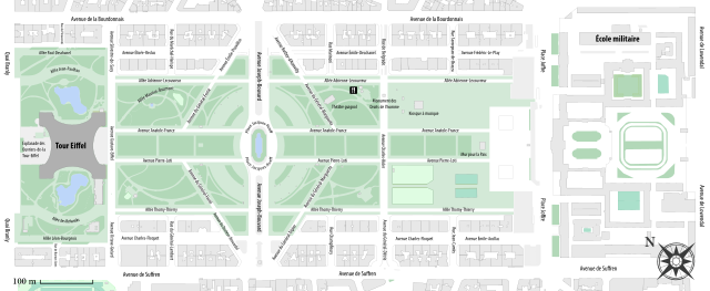
Champ-de-Mars, Paris. |
||||
| Description |
English: Plan of the Champ de Mars, Paris, France.
Français : Plan du Champ-de-Mars, Paris, France. |
||||
| 日期 | |||||
| 來源 |
|
||||
| Creator | |||||
| Geotemporal data | |||||
| Date depicted | |||||
| Map type | city map | ||||
| Spatial reference system | Mercator | ||||
| Bounding box |
|
||||
| Georeferencing | If inappropriate please set warp_status = skip to hide. | ||||
| Bibliographic data | |||||
| 語言 | 法文 | ||||

協議
我,呢份作品嘅作者,決定用以下許可發佈呢件作品:
This file is licensed under the Creative Commons Attribution-Share Alike 4.0 International license.
- 你可以:
- 去分享 – 複製、發佈同傳播呢個作品
- 再改 – 創作演繹作品
- 要遵照下面嘅條件:
- 署名 – 你一定要畀合適嘅表彰、畀返指向呢個授權條款嘅連結,同埋寫明有無改過嚟。你可以用任何合理方式去做,但唔可以用任何方式暗示授權人認可咗你或者你嘅使用方式。
- 相同方式分享 – 如果你用任何方式改過呢個作品,你必須要用返原本或者相似嘅條款發佈。
| This work contains information from OpenStreetMap, which is made available under the Open Database License (ODbL).
The ODbL does not require any particular license for maps produced from ODbL data. Prior to 1 August 2020, map tiles produced by the OpenStreetMap Foundation were licensed under the CC-BY-SA-2.0 license. Maps produced by other people may be subject to other licences. |
檔案歷史
撳個日期/時間去睇響嗰個時間出現過嘅檔案。
| 日期/時間 | 縮圖 | 尺寸 | 用戶 | 註解 | |
|---|---|---|---|---|---|
| 現時 | 2021年11月27號 (六) 16:54 | 1,920 × 790(462 KB) | Paris 16 | ||
| 2020年10月20號 (二) 08:07 | 512 × 211(460 KB) | Paris 16 | |||
| 2020年10月20號 (二) 06:00 | 512 × 211(456 KB) | Paris 16 | |||
| 2020年10月20號 (二) 05:15 | 512 × 211(446 KB) | Paris 16 | |||
| 2020年10月20號 (二) 05:14 | 512 × 211(175 KB) | Paris 16 | Uploaded own work with UploadWizard |
檔案用途
以下嘅1版用到呢個檔:
全域檔案使用情況
下面嘅維基都用緊呢個檔案:
- af.wikipedia.org嘅使用情況
- be-tarask.wikipedia.org嘅使用情況
- be.wikipedia.org嘅使用情況
- bg.wikipedia.org嘅使用情況
- bs.wikipedia.org嘅使用情況
- ca.wikipedia.org嘅使用情況
- ceb.wikipedia.org嘅使用情況
- cs.wikipedia.org嘅使用情況
- da.wikipedia.org嘅使用情況
- de.wikipedia.org嘅使用情況
- el.wikipedia.org嘅使用情況
- en.wikipedia.org嘅使用情況
- eo.wikipedia.org嘅使用情況
- es.wikipedia.org嘅使用情況
- eu.wikipedia.org嘅使用情況
- fa.wikipedia.org嘅使用情況
- fi.wikipedia.org嘅使用情況
- fr.wikipedia.org嘅使用情況
- ha.wikipedia.org嘅使用情況
- he.wikipedia.org嘅使用情況
- hr.wikipedia.org嘅使用情況
- hu.wikipedia.org嘅使用情況
- hy.wikipedia.org嘅使用情況
- id.wikipedia.org嘅使用情況
- it.wikipedia.org嘅使用情況
- ja.wikipedia.org嘅使用情況
- ka.wikipedia.org嘅使用情況
- ko.wikipedia.org嘅使用情況
- lt.wikipedia.org嘅使用情況
- ms.wikipedia.org嘅使用情況
- nl.wikipedia.org嘅使用情況
- no.wikipedia.org嘅使用情況
- pl.wikipedia.org嘅使用情況
- pt.wikipedia.org嘅使用情況
- ru.wikipedia.org嘅使用情況
- sh.wikipedia.org嘅使用情況
- sv.wikipedia.org嘅使用情況
- th.wikipedia.org嘅使用情況
- tr.wikipedia.org嘅使用情況
- uk.wikipedia.org嘅使用情況
- vi.wikipedia.org嘅使用情況
- www.wikidata.org嘅使用情況
- wuu.wikipedia.org嘅使用情況
- zh.wikipedia.org嘅使用情況