File:Elevation.jpg

原本檔案 (10,800 × 5,400 像素,檔案大細:25.61 MB ,MIME類型:image/jpeg)
摘要
| 描述 |
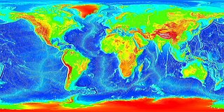
English: Global land and undersea elevation. (flat projection
Deutsch: Globales Höhenprofil (Flachkarte) |
| 日期 | 未知日期 |
| 來源 | http://www.ngdc.noaa.gov/mgg/image/2minrelief.html |
| 作者 | National Oceanic and Atmospheric Administration |
To calculate geografic coordinates to map coordinates: X = (180 + longitude) * width of map / 360 // west is minus Y = (90 + latitude) * height of map / 360 // north is minus
協議
This image is in the public domain because it contains materials that originally came from the U.S. National Oceanic and Atmospheric Administration, taken or made as part of an employee's official duties.
|
![]()
See also
- Image:LARGE elevation.jpg — a high-resolution (13MB) version of this image
- Image:Earth surface NGDC 2000.jpg — made from similar data
檔案歷史
撳個日期/時間去睇響嗰個時間出現過嘅檔案。
| 日期/時間 | 縮圖 | 尺寸 | 用戶 | 註解 | |
|---|---|---|---|---|---|
| 現時 | 2023年8月19號 (六) 20:02 | | 10,800 × 5,400(25.61 MB) | Kersti Nebelsiek | higher resolution |
| 2021年11月13號 (六) 23:11 |  | 5,400 × 2,700(14.08 MB) | Antonsusi | resolution | |
| 2006年3月7號 (二) 01:59 |  | 4,320 × 2,160(1.86 MB) | Interiot~commonswiki | Global land and undersea elevation. Source: http://www.ngdc.noaa.gov/mgg/image/2minrelief.html |
檔案用途
以下嘅1版用到呢個檔:
全域檔案使用情況
下面嘅維基都用緊呢個檔案:
- af.wikipedia.org嘅使用情況
- an.wikipedia.org嘅使用情況
- ar.wikipedia.org嘅使用情況
- ast.wikipedia.org嘅使用情況
- awa.wikipedia.org嘅使用情況
- az.wikipedia.org嘅使用情況
- ba.wikipedia.org嘅使用情況
- be-tarask.wikipedia.org嘅使用情況
- be.wikipedia.org嘅使用情況
- bg.wikipedia.org嘅使用情況
- bh.wikipedia.org嘅使用情況
- br.wikipedia.org嘅使用情況
- bs.wikipedia.org嘅使用情況
- ca.wikipedia.org嘅使用情況
- ce.wikipedia.org嘅使用情況
- ckb.wikipedia.org嘅使用情況
- cs.wikipedia.org嘅使用情況
- da.wikipedia.org嘅使用情況
- de.wikipedia.org嘅使用情況
- el.wikipedia.org嘅使用情況
- en.wikipedia.org嘅使用情況
- en.wikiversity.org嘅使用情況
- eo.wikipedia.org嘅使用情況
- es.wikipedia.org嘅使用情況
- et.wikipedia.org嘅使用情況
- eu.wikipedia.org嘅使用情況
- fa.wikipedia.org嘅使用情況
- fi.wikipedia.org嘅使用情況
- fr.wikipedia.org嘅使用情況
- ga.wikipedia.org嘅使用情況
睇呢個檔案嘅更多全域使用情況。