File:Galapagos Islands topographic map-en.svg

呢個「SVG」檔案嘅呢個「PNG」預覽嘅大細:600 × 600 像素。 第啲解像度:240 × 240 像素|480 × 480 像素|768 × 768 像素|1,024 × 1,024 像素|2,048 × 2,048 像素|2,160 × 2,160 像素。
原本檔案 (SVG檔案,表面大細: 2,160 × 2,160 像素,檔案大細:2.62 MB)
摘要
| 描述 |
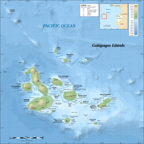
*The background map is a raster image embedded in the SVG file. *UTM projection, WGS84 datum *Scales: **Topography: 1:800,000 (accuracy: 200m) **Bathymetry: 1:4,000,000 (accuracy: 1,000m) |
| 日期 | (UTC) |
| 來源 | |
| 作者 |
|
| Other versions |
[]
|

.png)


| This is a retouched picture, which means that it has been digitally altered from its original version. Modifications: Translated from German into English. The original can be viewed here: Galapagos Islands topographic map-de.svg:
|
I, the copyright holder of this work, hereby publish it under the following licenses:
This file is licensed under the Creative Commons Attribution-Share Alike 3.0 Unported, 2.5 Generic, 2.0 Generic and 1.0 Generic license.
- 你可以:
- 去分享 – 複製、發佈同傳播呢個作品
- 再改 – 創作演繹作品
- 要遵照下面嘅條件:
- 署名 – 你一定要畀合適嘅表彰、畀返指向呢個授權條款嘅連結,同埋寫明有無改過嚟。你可以用任何合理方式去做,但唔可以用任何方式暗示授權人認可咗你或者你嘅使用方式。
- 相同方式分享 – 如果你用任何方式改過呢個作品,你必須要用返原本或者相似嘅條款發佈。

|
根據自由軟體基金會發佈嘅無固定段落、封面文字同封底文字GNU自由文件授權條款第1.2或打後嘅版本,你獲授權可以重製、散佈同埋修改爾份文件。授權條款嘅副本喺章節GNU自由文件授權條款。 |
你可以揀你想用嘅牌照。
Original upload log
This image is a derivative work of the following images:
- File:Galapagos_Islands_topographic_map-de.svg licensed with Cc-by-sa-3.0,2.5,2.0,1.0, GFDL
- 2008-11-03T19:33:06Z NordNordWest 2160x2160 (2744048 Bytes) corrected
- 2008-10-26T17:07:45Z NordNordWest 2160x2160 (2746684 Bytes) {{Location|00|30|00|S|90|30|00|W|scale:1000000}} {{Information |Description= {{de|Topografische and bathymetrische Karte der [[:de:Galápagos-Inseln|Galápagos-Inseln]], [[:de:Ecuador|Ecuador]].}} {{en|Topographic and bathyme
Uploaded with derivativeFX
檔案歷史
撳個日期/時間去睇響嗰個時間出現過嘅檔案。
| 日期/時間 | 縮圖 | 尺寸 | 用戶 | 註解 | |
|---|---|---|---|---|---|
| 現時 | 2016年10月4號 (二) 11:40 | | 2,160 × 2,160(2.62 MB) | Teofilo | <s>Marlborough</s> → Narborough |
| 2011年9月2號 (五) 00:15 |  | 2,160 × 2,160(2.62 MB) | MatthewStevens | {{Information |Description={{de|Topografische and bathymetrische Karte der Galápagos-Inseln, Ecuador.}} {{en|Topographic and bathymetric map of the Galápagos Islands, [[:en:Ecuador|Ecu |
檔案用途
以下嘅1版用到呢個檔:
全域檔案使用情況
下面嘅維基都用緊呢個檔案:
- azb.wikipedia.org嘅使用情況
- bg.wikipedia.org嘅使用情況
- br.wikipedia.org嘅使用情況
- da.wikipedia.org嘅使用情況
- en.wikipedia.org嘅使用情況
- en.wikiversity.org嘅使用情況
- es.wikipedia.org嘅使用情況
- fa.wikipedia.org嘅使用情況
- fy.wikipedia.org嘅使用情況
- gl.wikipedia.org嘅使用情況
- hy.wikipedia.org嘅使用情況
- id.wikipedia.org嘅使用情況
- is.wikipedia.org嘅使用情況
- it.wikipedia.org嘅使用情況
- mi.wikipedia.org嘅使用情況
- mr.wikipedia.org嘅使用情況
- ms.wikipedia.org嘅使用情況
- my.wikipedia.org嘅使用情況
- nds-nl.wikipedia.org嘅使用情況
- nl.wikipedia.org嘅使用情況
- no.wikipedia.org嘅使用情況
- pl.wikipedia.org嘅使用情況
- pt.wikipedia.org嘅使用情況
睇呢個檔案嘅更多全域使用情況。