File:Jakarta Skyline Part 2.jpg

原本檔案 (1,546 × 768 像素,檔案大細:801 KB ,MIME類型:image/jpeg)

|
Copyright warning: A subject in this image is protected by copyright.
This image features an architectural or artistic work, photographed from a public space in Indonesia. There are no freedom of panorama exceptions of any kind under the Chapter VI (Copyright Limitations), Articles 43–51 of the Indonesian Copyright Act No. 28, 2014, which means that these architectural or artistic works cannot be photographed freely for anything other than non-commercial or personal uses. If a copyrighted architectural or artistic work is contained in this image and it is a substantial reproduction, this photo cannot be licensed under a free license, and will be deleted. Framing this image to focus on the copyrighted work is also a copyright violation. Before reusing this content, ensure that you have the right to do so. You are solely responsible for ensuring that you do not infringe someone else's copyrights. See our general disclaimer for more information. |

摘要
| 描述 |
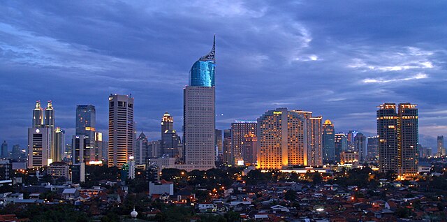
English: Lining up Jakarta's skyscrapers along the CBD with Wisma 46 as the centerpiece.
Wisma 46 is designed by Zeidler Partnership and has been well-known for being Indonesia's tallest building; and Jakarta's most distinguished skyscrapers with its unique shape resembling an elegant fountain pen. Singapore may have a "Durian" (The Esplanade); and Beijing has a "Bird's Nest" (Olympic Stadium) and "Trousers Pants" (CCTV Tower); but Jakarta has an elegant "Fountain Pen". Although it may not be the tallest building in Indonesia now, -with the completion of Menara BCA and The Kempinski Residences at the Grand Indonesia Mall complex; and construction at The Jakarta Tower (558m) is coming soon-, Wisma 46 remains one of the nation's most distinguished and unique building. |
| 日期 | |
| 來源 | https://www.flickr.com/photos/joe-joe/2303992129/ |
| 作者 | yohanes budiyanto |
| Object location | | View this and other nearby images on: OpenStreetMap |
|---|
協議
- 你可以:
- 去分享 – 複製、發佈同傳播呢個作品
- 再改 – 創作演繹作品
- 要遵照下面嘅條件:
- 署名 – 你一定要畀合適嘅表彰、畀返指向呢個授權條款嘅連結,同埋寫明有無改過嚟。你可以用任何合理方式去做,但唔可以用任何方式暗示授權人認可咗你或者你嘅使用方式。
| This image was originally posted to Flickr by yohanes budiyanto at https://www.flickr.com/photos/27228523@N00/2303992129. It was reviewed on 2009年12月20號 by FlickreviewR and was confirmed to be licensed under the terms of the cc-by-2.0. |
檔案歷史
撳個日期/時間去睇響嗰個時間出現過嘅檔案。
| 日期/時間 | 縮圖 | 尺寸 | 用戶 | 註解 | |
|---|---|---|---|---|---|
| 現時 | 2023年5月3號 (三) 21:45 | | 1,546 × 768(801 KB) | B18IDH | Maybe This Is More Correct? |
| 2009年12月19號 (六) 19:05 |  | 906 × 450(519 KB) | Rochelimit | {{Information |Description={{en|1=Lining up Jakarta's skyscrapers. I took similar picture before with my Leica. This time, I tried it with my E-500 when the setting is blue, unlike previously in magenta. I'm also trying the 'golden rule' where the most pr |
檔案用途
以下嘅1版用到呢個檔:
全域檔案使用情況
下面嘅維基都用緊呢個檔案:
- ar.wikipedia.org嘅使用情況
- arz.wikipedia.org嘅使用情況
- ast.wikipedia.org嘅使用情況
- azb.wikipedia.org嘅使用情況
- ban.wikipedia.org嘅使用情況
- ba.wikipedia.org嘅使用情況
- bjn.wikipedia.org嘅使用情況
- blk.wikipedia.org嘅使用情況
- bn.wikipedia.org嘅使用情況
- bn.wikibooks.org嘅使用情況
- bs.wikipedia.org嘅使用情況
- bug.wikipedia.org嘅使用情況
- bxr.wikipedia.org嘅使用情況
- ceb.wikipedia.org嘅使用情況
- ckb.wikipedia.org嘅使用情況
- crh.wikipedia.org嘅使用情況
- csb.wikipedia.org嘅使用情況
- cu.wikipedia.org嘅使用情況
- cy.wikipedia.org嘅使用情況
- dag.wikipedia.org嘅使用情況
- de.wikipedia.org嘅使用情況
- diq.wikipedia.org嘅使用情況
- dv.wikipedia.org嘅使用情況
- en.wikipedia.org嘅使用情況
- en.wikivoyage.org嘅使用情況
- eo.wikipedia.org嘅使用情況
- es.wikipedia.org嘅使用情況
- eu.wikipedia.org嘅使用情況
- fa.wikipedia.org嘅使用情況
睇呢個檔案嘅更多全域使用情況。