File:Jo-map.png
冇更高解像度嘅圖像。
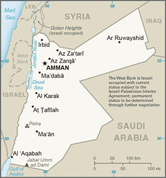
Jo-map.png (326 × 350 像素,檔案大細:60 KB ,MIME類型:image/png)

|
This locator map image could be recreated using vector graphics as an SVG file. This has several advantages; see Commons:Media for cleanup for more information. If an SVG form of this image is already available, please upload it. After uploading an SVG, replace this template with {{vector version available|new image name.svg}}.
|
摘要
- Credits
- From CIA World Factbook.
This image is in the public domain because it contains materials that originally came from the United States Central Intelligence Agency's World Factbook.
|
 |
- in Esperanto: image:Jordanio.png
- in German: de:Bild:Jordanien.png
- in Arab: image:Jordan sm01.jpg
檔案歷史
撳個日期/時間去睇響嗰個時間出現過嘅檔案。
| 日期/時間 | 縮圖 | 尺寸 | 用戶 | 註解 | |
|---|---|---|---|---|---|
| 現時 | 2017年10月29號 (日) 22:01 | | 326 × 350(60 KB) | Neuenglander | Updated version |
| 2007年6月21號 (四) 07:27 |  | 328 × 352(18 KB) | Hoshie | Updated map of Jordan from the CIA World Factbook, 14 June 07 rev. Src: https://www.cia.gov/library/publications/the-world-factbook/maps/jo-map.gif | |
| 2005年4月15號 (五) 14:15 |  | 329 × 354(12 KB) | Oxhop | Map of Jordan from CIA World Factbook{{PD-USGov-CIA-WF}}Category:Jordan |
檔案用途
以下嘅1版用到呢個檔:
全域檔案使用情況
下面嘅維基都用緊呢個檔案:
- af.wikipedia.org嘅使用情況
- ar.wikipedia.org嘅使用情況
- ast.wikipedia.org嘅使用情況
- azb.wikipedia.org嘅使用情況
- be-tarask.wikipedia.org嘅使用情況
- bg.wikipedia.org嘅使用情況
- bg.wiktionary.org嘅使用情況
- bjn.wikipedia.org嘅使用情況
- bn.wikipedia.org嘅使用情況
- br.wikipedia.org嘅使用情況
- ckb.wikipedia.org嘅使用情況
- cs.wikipedia.org嘅使用情況
- cv.wikipedia.org嘅使用情況
- da.wikipedia.org嘅使用情況
- de.wikipedia.org嘅使用情況
- dsb.wikipedia.org嘅使用情況
- el.wikipedia.org嘅使用情況
- en.wikipedia.org嘅使用情況
- es.wikipedia.org嘅使用情況
- eu.wikipedia.org嘅使用情況
- fa.wikipedia.org嘅使用情況
- fiu-vro.wikipedia.org嘅使用情況
- fi.wikipedia.org嘅使用情況
- fr.wikipedia.org嘅使用情況
- gd.wikipedia.org嘅使用情況
- gl.wikipedia.org嘅使用情況
睇呢個檔案嘅更多全域使用情況。