File:Karta FP Gambier isl.PNG
冇更高解像度嘅圖像。
Karta_FP_Gambier_isl.PNG (450 × 400 像素,檔案大細:5 KB ,MIME類型:image/png)
摘要
| 描述 |
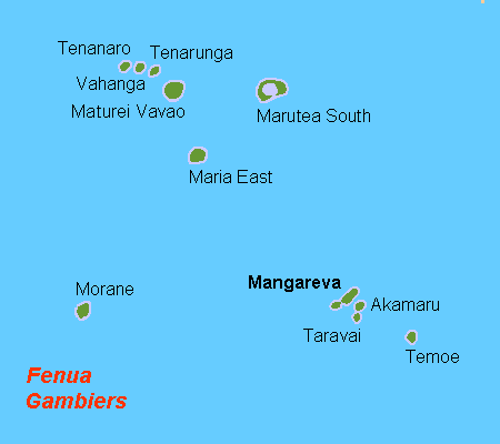
Deutsch: Karte der Gambierinseln, Französisch Polynesien
English: Map (rough) of the Gambier Islands, French Polynesia, own work composed from various mapreferences
Svenska: Karta över Gambieröarna, FP |
| 日期 | |
| 來源 | 自己作品 |
| 作者 | Hobe / Holger Behr |
協議
| I, the copyright holder of this work, release this work into the public domain. This applies worldwide. In some countries this may not be legally possible; if so: I grant anyone the right to use this work for any purpose, without any conditions, unless such conditions are required by law. |
檔案歷史
撳個日期/時間去睇響嗰個時間出現過嘅檔案。
| 日期/時間 | 縮圖 | 尺寸 | 用戶 | 註解 | |
|---|---|---|---|---|---|
| 現時 | 2007年4月21號 (六) 13:01 | | 450 × 400(5 KB) | Hobe | karta gambieröarna, Holger Behr, own work |
檔案用途
以下嘅1版用到呢個檔:
全域檔案使用情況
下面嘅維基都用緊呢個檔案:
- ar.wikipedia.org嘅使用情況
- bg.wikipedia.org嘅使用情況
- de.wikipedia.org嘅使用情況
- el.wikipedia.org嘅使用情況
- en.wikipedia.org嘅使用情況
- es.wikipedia.org嘅使用情況
- fi.wikipedia.org嘅使用情況
- gl.wikipedia.org嘅使用情況
- he.wikipedia.org嘅使用情況
- hu.wikipedia.org嘅使用情況
- it.wikipedia.org嘅使用情況
- it.wikivoyage.org嘅使用情況
- ka.wikipedia.org嘅使用情況
- ko.wikipedia.org嘅使用情況
- lt.wikipedia.org嘅使用情況
- mk.wikipedia.org嘅使用情況
- mrj.wikipedia.org嘅使用情況
- nl.wikipedia.org嘅使用情況
- pt.wikipedia.org嘅使用情況
- ru.wikipedia.org嘅使用情況
- sr.wikipedia.org嘅使用情況
- sv.wikipedia.org嘅使用情況
- war.wikipedia.org嘅使用情況
- zh.wikipedia.org嘅使用情況