File:Kat hing wai kamtin.png
Kat_hing_wai_kamtin.png (500 × 500 像素,檔案大細:28 KB ,MIME類型:image/png)
檔案歷史
撳個日期/時間去睇響嗰個時間出現過嘅檔案。
| 日期/時間 | 縮圖 | 尺寸 | 用戶 | 註解 | |
|---|---|---|---|---|---|
| 現時 | 2007年6月22號 (五) 14:54 |  | 500 × 500(28 KB) | Samwingkit | |
| 2007年6月22號 (五) 14:53 |  | 500 × 500(42 KB) | Samwingkit | ||
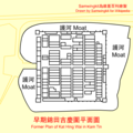
| 2007年6月22號 (五) 14:51 |  | 500 × 500(28 KB) | Samwingkit | {{Information |Description=香港新界元朗錦田吉慶圍平面圖<br>Former plan of Kat Hing Wai in [[:en:Kam |
檔案用途
以下嘅1版用到呢個檔:
全域檔案使用情況
下面嘅維基都用緊呢個檔案:
- en.wikipedia.org嘅使用情況
- fr.wikipedia.org嘅使用情況
- vi.wikipedia.org嘅使用情況
- zh.wikipedia.org嘅使用情況
