File:LAR ga map.png
預覽大細:800 × 309 像素。 第啲解像度:320 × 124 像素|640 × 247 像素|1,024 × 396 像素|2,200 × 850 像素。
原本檔案 (2,200 × 850 像素,檔案大細:904 KB ,MIME類型:image/png)
摘要
| 描述 |
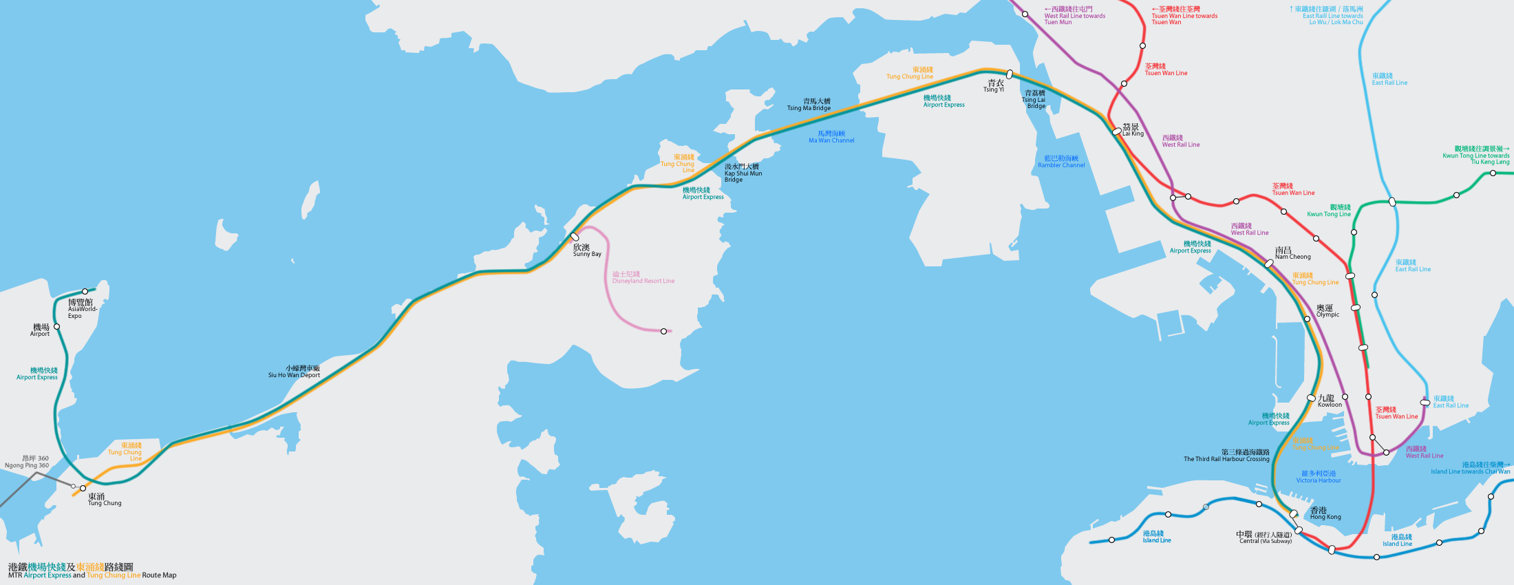
港鐵機場快綫及東涌綫路線圖(按真實地形繪畫) Geographically accurate map of the MTR Airport Express and Tung Chung Line By Bus_28a, Mtrkwt |
| 日期 | 2006年2月25號 (original upload date) |
| 來源 | No machine-readable source provided. Own work assumed (based on copyright claims). |
| 作者 | No machine-readable author provided. Mtrkwt assumed (based on copyright claims). |
協議
I, the copyright holder of this work, hereby publish it under the following licenses:

|
根據自由軟體基金會發佈嘅無固定段落、封面文字同封底文字GNU自由文件授權條款第1.2或打後嘅版本,你獲授權可以重製、散佈同埋修改爾份文件。授權條款嘅副本喺章節GNU自由文件授權條款。 |
| 呢個檔案用共享創意 姓名標示-非商業性-相同方式分享3.0 未本地化版本條款授權。 | ||
| ||
| This licensing tag was added to this file as part of the GFDL licensing update. |
This file is licensed under the Creative Commons Attribution-Share Alike 2.5 Generic, 2.0 Generic and 1.0 Generic license.
- 你可以:
- 去分享 – 複製、發佈同傳播呢個作品
- 再改 – 創作演繹作品
- 要遵照下面嘅條件:
- 署名 – 你一定要畀合適嘅表彰、畀返指向呢個授權條款嘅連結,同埋寫明有無改過嚟。你可以用任何合理方式去做,但唔可以用任何方式暗示授權人認可咗你或者你嘅使用方式。
- 相同方式分享 – 如果你用任何方式改過呢個作品,你必須要用返原本或者相似嘅條款發佈。
你可以揀你想用嘅牌照。

|
This map image could be recreated using vector graphics as an SVG file. This has several advantages; see Commons:Media for cleanup for more information. If an SVG form of this image is already available, please upload it. After uploading an SVG, replace this template with {{vector version available|new image name.svg}}.
|
檔案歷史
撳個日期/時間去睇響嗰個時間出現過嘅檔案。
| 日期/時間 | 縮圖 | 尺寸 | 用戶 | 註解 | |
|---|---|---|---|---|---|
| 現時 | 2014年12月28號 (日) 16:22 | 2,200 × 850(904 KB) | Mtrkwt | Update for ISL | |
| 2009年8月16號 (日) 08:16 | 2,200 × 850(676 KB) | Mtrkwt | Update for KSL. | ||
| 2009年2月22號 (日) 13:01 | 2,200 × 850(313 KB) | Hokachung | Ngong Ping 360 | ||
| 2007年12月3號 (一) 08:25 | 2,200 × 850(658 KB) | Mtrkwt | |||
| 2007年1月28號 (日) 06:42 | 2,200 × 850(500 KB) | Mtrkwt | |||
| 2006年2月26號 (日) 10:07 | 2,200 × 850(496 KB) | Mtrkwt | Geographically accurate map of the MTR Airport Express and Tung Chung Line | ||
| 2006年2月25號 (六) 19:44 | 2,200 × 850(492 KB) | Mtrkwt | 地鐵機場快綫及東涌綫路線圖路線圖(按真實地形繪畫) | ||
| 2006年2月25號 (六) 19:34 | 2,200 × 850(493 KB) | Mtrkwt | 地鐵機場快綫及東涌綫路線圖(按真實地形繪畫) |
檔案用途
全域檔案使用情況
下面嘅維基都用緊呢個檔案:
- de.wikipedia.org嘅使用情況
- fi.wikipedia.org嘅使用情況
- fr.wikipedia.org嘅使用情況
- ja.wikipedia.org嘅使用情況
- nl.wikipedia.org嘅使用情況
- pl.wikipedia.org嘅使用情況
- ru.wikipedia.org嘅使用情況
- simple.wikipedia.org嘅使用情況
- sk.wikipedia.org嘅使用情況
- th.wikipedia.org嘅使用情況
- www.wikidata.org嘅使用情況
- zh-min-nan.wikipedia.org嘅使用情況