File:Liechtenstein - Location Map (2013) - LIE - UNOCHA.svg

原本檔案 (SVG檔案,表面大細: 250 × 250 像素,檔案大細:952 KB)
_-_LIE_-_UNOCHA.svg?uselang=yue)
摘要
| 描述 |
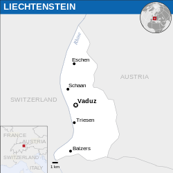
English: Locator map of Liechtenstein. |
| 日期 | |
| 來源 |
English: Liechtenstein Locator Map (ReliefWeb), ESRI, UNCS |
| 作者 | |
| SVG genesis |
協議
- 你可以:
- 去分享 – 複製、發佈同傳播呢個作品
- 再改 – 創作演繹作品
- 要遵照下面嘅條件:
- 署名 – 你一定要畀合適嘅表彰、畀返指向呢個授權條款嘅連結,同埋寫明有無改過嚟。你可以用任何合理方式去做,但唔可以用任何方式暗示授權人認可咗你或者你嘅使用方式。
 This map is part of a collection of 216 free country maps, created by the UN Office for the Coordination of Humanitarian Affairs (OCHA), to be used in print, web or broadcast products.
The ReliefWeb Location Maps released here are maps that highlight a country, its capital, major populated places and the surrounding regions. Attribution Requirements
Using the map without modifications: ensure that the sources and the disclaimer are below the map. Credit as follows: "Credit: OCHA". For use with alteration: remove the OCHA logo and disclaimer following any modification to the map, but keep the data sources as mentioned below the map. Credit the modified map as follows: "Based on OCHA map". You are responsible for the content of your map. We are keen to receive your feedback and hear how you used OCHA's maps. We would be grateful if you would notify us by e-mail and share your work with us. UN Disclaimer
The designations employed and the presentation of material of this map do not imply the expression of any opinion whatsoever on the part of the Secretariat of the United Nations concerning the legal status of any country, territory, city or area or of its authorities or concerning the delimitation of its frontiers or boundaries. |

|
Textual information (e.g. timestamp) once visible in the image itself has been moved into the image metadata and/or image description page. This makes the image easier to reuse and more language-neutral, and makes the text easier to process and search for. Commons discourages placing visible textual information in images. All licenses accepted on Commons permit this type of modification as a derivative work.
If attribution information were removed and the image is not public domain, replace this tag with {{Attribution metadata from licensed image}}.
|
檔案歷史
撳個日期/時間去睇響嗰個時間出現過嘅檔案。
| 日期/時間 | 縮圖 | 尺寸 | 用戶 | 註解 | |
|---|---|---|---|---|---|
| 現時 | 2024年2月5號 (一) 15:53 | | 250 × 250(952 KB) | Illchy | File uploaded using svgtranslate tool (https://svgtranslate.toolforge.org/). Added translation for id. |
| 2023年4月9號 (日) 07:57 |  | 250 × 250(951 KB) | Darafsh | File uploaded using svgtranslate tool (https://svgtranslate.toolforge.org/). Added translation for fa. | |
| 2016年3月25號 (五) 13:29 |  | 250 × 250(948 KB) | Wereldburger758 | Resized page to drawing. Removal watermark. Validation of image. | |
| 2014年4月21號 (一) 04:29 |  | 254 × 254(931 KB) | UN OCHA maps bot | == {{int:filedesc}} == {{Information |description={{en|1=Locator map of Liechtenstein.}} |date=2013 |source={{en|1=[http://reliefweb.int/map/liechtenstein/liechtenstein-location-map-2013 Liechtenstein Locator Map (ReliefWeb)]}} |... |
檔案用途
以下嘅1版用到呢個檔:
全域檔案使用情況
下面嘅維基都用緊呢個檔案:
- azb.wikipedia.org嘅使用情況
- bh.wikipedia.org嘅使用情況
- ckb.wikipedia.org嘅使用情況
- en.wikipedia.org嘅使用情況
- fa.wikipedia.org嘅使用情況
- id.wikipedia.org嘅使用情況
- io.wikipedia.org嘅使用情況
- km.wikipedia.org嘅使用情況
- mn.wikipedia.org嘅使用情況
- ne.wikipedia.org嘅使用情況
- pl.wikipedia.org嘅使用情況
- sco.wikipedia.org嘅使用情況
- sd.wikipedia.org嘅使用情況
- shn.wikipedia.org嘅使用情況
- th.wikipedia.org嘅使用情況
- to.wikipedia.org嘅使用情況
_-_LIE_-_UNOCHA.svg)