File:Malacca Sultanate en.svg

呢個「SVG」檔案嘅呢個「PNG」預覽嘅大細:512 × 581 像素。 第啲解像度:211 × 240 像素|423 × 480 像素|677 × 768 像素|902 × 1,024 像素|1,805 × 2,048 像素。
原本檔案 (SVG檔案,表面大細: 512 × 581 像素,檔案大細:373 KB)
摘要
| 描述 |
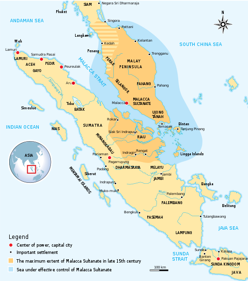
English: The historical map of Malacca Sultanate (1402–1511) Malay Peninsula and East Coast of Sumatra. Made and improved based on "Atlas Sejarah Indonesia dan Dunia" (The Atlas of Indonesian and World History), PT Pembina Peraga Jakarta 1996. |
| 日期 | |
| 來源 | 自己作品 |
| 作者 | Gunawan Kartapranata |
| 許可 (重用呢個檔案) |
我,呢份作品嘅作者,決定用以下許可發佈呢件作品: 呢個檔案用共享創意 姓名標示-非商業性-相同方式分享3.0 未本地化版本條款授權。
|
| Other versions |
[]
|


|
This SVG file contains embedded text that can be translated into your language, using any capable SVG editor, text editor or the SVG Translate tool. For more information see: About translating SVG files. |
檔案歷史
撳個日期/時間去睇響嗰個時間出現過嘅檔案。
| 日期/時間 | 縮圖 | 尺寸 | 用戶 | 註解 | |
|---|---|---|---|---|---|
| 現時 | 2020年10月18號 (日) 17:18 | | 512 × 581(373 KB) | Tofeiku | File uploaded using svgtranslate tool (https://svgtranslate.toolforge.org/). Added translation for ms. |
| 2017年5月12號 (五) 11:50 |  | 512 × 581(367 KB) | Gunkarta | Turn Aru red, it was a major polity | |
| 2017年5月12號 (五) 11:49 |  | 512 × 581(367 KB) | Gunkarta | Turn Aru red, it was a major polity | |
| 2011年10月13號 (四) 20:16 |  | 496 × 563(364 KB) | Gunkarta | minor edits | |
| 2011年10月13號 (四) 20:06 |  | 496 × 564(363 KB) | Gunkarta |
檔案用途
以下嘅1版用到呢個檔:
全域檔案使用情況
下面嘅維基都用緊呢個檔案:
- ar.wikipedia.org嘅使用情況
- ast.wikipedia.org嘅使用情況
- azb.wikipedia.org嘅使用情況
- az.wikipedia.org嘅使用情況
- ba.wikipedia.org嘅使用情況
- be.wikipedia.org嘅使用情況
- bn.wikipedia.org嘅使用情況
- ca.wikipedia.org嘅使用情況
- ckb.wikipedia.org嘅使用情況
- cs.wikipedia.org嘅使用情況
- de.wikiversity.org嘅使用情況
- el.wikipedia.org嘅使用情況
- en.wikipedia.org嘅使用情況
- es.wikipedia.org嘅使用情況
- eu.wikipedia.org嘅使用情況
- fa.wikipedia.org嘅使用情況
- fi.wikipedia.org嘅使用情況
- fr.wikipedia.org嘅使用情況
- hr.wikipedia.org嘅使用情況
- id.wikipedia.org嘅使用情況
- incubator.wikimedia.org嘅使用情況
- it.wikipedia.org嘅使用情況
- ja.wikipedia.org嘅使用情況
- ko.wikipedia.org嘅使用情況
- la.wikipedia.org嘅使用情況
- lt.wikipedia.org嘅使用情況
- ml.wikipedia.org嘅使用情況
- ms.wikipedia.org嘅使用情況
- my.wikipedia.org嘅使用情況
- pl.wikipedia.org嘅使用情況
- pnb.wikipedia.org嘅使用情況
- ru.wikipedia.org嘅使用情況
- sr.wikipedia.org嘅使用情況
- sv.wikipedia.org嘅使用情況
- ta.wikipedia.org嘅使用情況
睇呢個檔案嘅更多全域使用情況。