File:Malta-CIA WFB Map.png
冇更高解像度嘅圖像。
Malta-CIA_WFB_Map.png (330 × 355 像素,檔案大細:6 KB ,MIME類型:image/png)
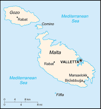
| 描述 | Map of Malta showing island names and towns. | |||
| 日期 | ||||
| 來源 | CIA, The World Factbook, 2004 | |||
| 作者 | CIA | |||
| 許可 (重用呢個檔案) |
|

derivative works
Derivative works of this file: Maltait.png
檔案歷史
撳個日期/時間去睇響嗰個時間出現過嘅檔案。
| 日期/時間 | 縮圖 | 尺寸 | 用戶 | 註解 | |
|---|---|---|---|---|---|
| 現時 | 2005年3月27號 (日) 09:16 | | 330 × 355(6 KB) | Wolfman~commonswiki | {{CIA-map}} |
檔案用途
以下嘅1版用到呢個檔:
全域檔案使用情況
下面嘅維基都用緊呢個檔案:
- af.wikipedia.org嘅使用情況
- als.wikipedia.org嘅使用情況
- ar.wikipedia.org嘅使用情況
- ast.wikipedia.org嘅使用情況
- br.wikipedia.org嘅使用情況
- de.wikipedia.org嘅使用情況
- dsb.wikipedia.org嘅使用情況
- el.wikipedia.org嘅使用情況
- eml.wikipedia.org嘅使用情況
- en.wikipedia.org嘅使用情況
- en.wikisource.org嘅使用情況
- en.wiktionary.org嘅使用情況
- eo.wikipedia.org嘅使用情況
- es.wikipedia.org嘅使用情況
- fa.wikipedia.org嘅使用情況
- fi.wikipedia.org嘅使用情況
- fi.wikivoyage.org嘅使用情況
- fr.wikipedia.org嘅使用情況
- fy.wikipedia.org嘅使用情況
- gag.wikipedia.org嘅使用情況
- gd.wikipedia.org嘅使用情況
- gom.wikipedia.org嘅使用情況
- he.wikipedia.org嘅使用情況
- תבנית:הידעת? 22 בפברואר - סדרה 2
- שיחת תבנית:הידעת? 22 בפברואר - סדרה 2
- ויקיפדיה:הידעת?/החלפת קטעי "הידעת?"/ארכיון דיונים שהסתיימו - ההצעה התקבלה/4
- פורטל:המזרח התיכון/הידעת?/קטעי הידעת?
- פורטל:המזרח התיכון/הידעת?/12
- פורטל:תחבורה/הידעת?/קטעי הידעת
- פורטל:אירופה/הידעת?/קטעי הידעת?
- פורטל:היסטוריה/המחקר?/קטעי הידעת
- ויקיפדיה:הידעת?/2014/אוקטובר
睇呢個檔案嘅更多全域使用情況。