File:Mamoudzou (10029936275).jpg
預覽大細:800 × 600 像素。 第啲解像度:320 × 240 像素|640 × 480 像素|1,024 × 768 像素。
原本檔案 (1,024 × 768 像素,檔案大細:147 KB ,MIME類型:image/jpeg)
.jpg?uselang=yue)
摘要
| 描述 |
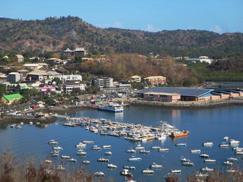
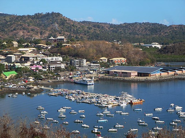
English: Mamoudzou on Grande-Terre island is the largest town and capital (préfecture) of Mayotte. The large building on the right is the public market. Part of the Comoros Group in the Indian Ocean, Mayotte has been a French possession since 1841 and is a French overseas department since 2011.
Français : Mamoudzou sur l'île de Grande-Terre est la préfecture et plus grande ville de Mayotte, territoire d'outre-mer français depuis 1841 devenu département d'outre mer de la République française en 2011, suite à un référendum. |
| 日期 | |
| 來源 |
|
| 作者 | David Stanley from Nanaimo, Canada |
| Camera location | | View this and other nearby images on: OpenStreetMap |
|---|
.jpg¶ms=-12.781763_N_0045.236313_E_globe:Earth_type:camera_source:Flickr_&language=yue)
協議
Ĉi tiu dosiero estas disponebla laŭ la permesilo Krea Komunaĵo Atribuite 2.0 Ĝenerala.
- 你可以:
- 去分享 – 複製、發佈同傳播呢個作品
- 再改 – 創作演繹作品
- 要遵照下面嘅條件:
- 署名 – 你一定要畀合適嘅表彰、畀返指向呢個授權條款嘅連結,同埋寫明有無改過嚟。你可以用任何合理方式去做,但唔可以用任何方式暗示授權人認可咗你或者你嘅使用方式。
| This image, originally posted to Flickr, was reviewed on 22 October 2013 by the administrator or reviewer File Upload Bot (Magnus Manske), who confirmed that it was available on Flickr under the stated license on that date. |
檔案歷史
撳個日期/時間去睇響嗰個時間出現過嘅檔案。
| 日期/時間 | 縮圖 | 尺寸 | 用戶 | 註解 | |
|---|---|---|---|---|---|
| 現時 | 2013年10月22號 (二) 01:09 | | 1,024 × 768(147 KB) | File Upload Bot (Magnus Manske) | Transferred from Flickr by User:AlbertHerring |
檔案用途
以下嘅1版用到呢個檔:
全域檔案使用情況
下面嘅維基都用緊呢個檔案:
- af.wikipedia.org嘅使用情況
- an.wikipedia.org嘅使用情況
- ar.wikipedia.org嘅使用情況
- arz.wikipedia.org嘅使用情況
- ast.wikipedia.org嘅使用情況
- azb.wikipedia.org嘅使用情況
- az.wikipedia.org嘅使用情況
- be.wikipedia.org嘅使用情況
- bg.wikipedia.org嘅使用情況
- bn.wikipedia.org嘅使用情況
- br.wikipedia.org嘅使用情況
- bs.wikipedia.org嘅使用情況
- ca.wikipedia.org嘅使用情況
- ceb.wikipedia.org嘅使用情況
- ce.wikipedia.org嘅使用情況
- cs.wikipedia.org嘅使用情況
- cv.wikipedia.org嘅使用情況
- de.wikipedia.org嘅使用情況
- de.wikivoyage.org嘅使用情況
- el.wikipedia.org嘅使用情況
- en.wikipedia.org嘅使用情況
- en.wikivoyage.org嘅使用情況
- es.wikipedia.org嘅使用情況
- eu.wikipedia.org嘅使用情況
- fi.wikipedia.org嘅使用情況
- fr.wikipedia.org嘅使用情況
- gl.wikipedia.org嘅使用情況
- he.wikivoyage.org嘅使用情況
- hy.wikipedia.org嘅使用情況
- incubator.wikimedia.org嘅使用情況
- it.wikipedia.org嘅使用情況
- it.wikivoyage.org嘅使用情況
- ja.wikipedia.org嘅使用情況
- ja.wikivoyage.org嘅使用情況
- la.wikipedia.org嘅使用情況
- mg.wikipedia.org嘅使用情況
- mk.wikipedia.org嘅使用情況
- mt.wikipedia.org嘅使用情況
- mzn.wikipedia.org嘅使用情況
- oc.wikipedia.org嘅使用情況
睇呢個檔案嘅更多全域使用情況。
.jpg)
.jpg)