File:Map Mariana Islands volcanoes.gif

預覽大細:394 × 599 像素。 第啲解像度:158 × 240 像素|400 × 608 像素。
原本檔案 (400 × 608 像素,檔案大細:19 KB ,MIME類型:image/gif)
摘要
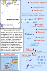
| 描述 | Map describing volcanoes of the Mariana Islands along the Marianas Trench (east of China and the Philippines). |
| 日期 | |
| 來源 | Derived by cropping US Government (USGS) map: http://vulcan.wr.usgs.gov/Imgs/Gif/MarianaIslands/Maps/map_mariana_islands_volcanoes.gif |
| 作者 | Wikid77 |
協議
The map is public domain, derived by User:Wikid77 from a USGS image (in GIF format).
This work is in the public domain in the United States because it is a work prepared by an officer or employee of the United States Government as part of that person’s official duties under the terms of Title 17, Chapter 1, Section 105 of the US Code.
Note: This only applies to original works of the Federal Government and not to the work of any individual U.S. state, territory, commonwealth, county, municipality, or any other subdivision. This template also does not apply to postage stamp designs published by the United States Postal Service since 1978. (See § 313.6(C)(1) of Compendium of U.S. Copyright Office Practices). It also does not apply to certain US coins; see The US Mint Terms of Use.
|
 | |
| This file has been identified as being free of known restrictions under copyright law, including all related and neighboring rights. | ||
檔案歷史
撳個日期/時間去睇響嗰個時間出現過嘅檔案。
| 日期/時間 | 縮圖 | 尺寸 | 用戶 | 註解 | |
|---|---|---|---|---|---|
| 現時 | 2010年6月29號 (二) 19:55 | | 400 × 608(19 KB) | Ras67 | cropped |
| 2008年3月7號 (五) 14:23 |  | 400 × 640(21 KB) | Wikid77 | initial upload |
檔案用途
以下嘅1版用到呢個檔:
全域檔案使用情況
下面嘅維基都用緊呢個檔案:
- af.wikipedia.org嘅使用情況
- az.wikipedia.org嘅使用情況
- br.wikipedia.org嘅使用情況
- da.wikipedia.org嘅使用情況
- en.wikipedia.org嘅使用情況
- fa.wikipedia.org嘅使用情況
- fi.wikipedia.org嘅使用情況
- fo.wikipedia.org嘅使用情況
- gl.wikipedia.org嘅使用情況
- io.wikipedia.org嘅使用情況
- is.wikipedia.org嘅使用情況
- ja.wikipedia.org嘅使用情況
- la.wikipedia.org嘅使用情況
- lt.wikipedia.org嘅使用情況
- mk.wikipedia.org嘅使用情況
- ms.wikipedia.org嘅使用情況
- nl.wikipedia.org嘅使用情況
- no.wikipedia.org嘅使用情況
- pt.wikipedia.org嘅使用情況
- sk.wikipedia.org嘅使用情況
- sr.wikipedia.org嘅使用情況
- th.wikipedia.org嘅使用情況
- tl.wikipedia.org嘅使用情況
- tr.wikipedia.org嘅使用情況
- tr.wiktionary.org嘅使用情況
- uk.wikipedia.org嘅使用情況
- uz.wikipedia.org嘅使用情況
- vi.wikipedia.org嘅使用情況