File:Map of Bengal.svg

呢個「SVG」檔案嘅呢個「PNG」預覽嘅大細:656 × 599 像素。 第啲解像度:263 × 240 像素|526 × 480 像素|841 × 768 像素|1,121 × 1,024 像素|2,242 × 2,048 像素|1,835 × 1,676 像素。
原本檔案 (SVG檔案,表面大細: 1,835 × 1,676 像素,檔案大細:1.32 MB)
摘要
| 描述 |
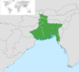
English: Map of Bengal. The region is today divided between East Bengal (Bangladesh) and West Bengal. Also showing the state of Tripura and the three districts of Cachar, Hailakandi and Karimganj; part of Barak Valley in Assam, India. Svenska: Karta av Bengal, delad mellan östra och västra. Staten Tripura och distrikten Hailakandi och Karimganj i södra Assam visas också. বাংলা: বাংলার মানচিত্র, পূর্ব ও পশ্চিমের মধ্যে বিভক্ত করা। মানচিত্রে চিহ্নিত রয়েছে বাংলাদেশের পূর্বে অবস্থিত বাংলাভাষী ভারতীয় রাজ্য ত্রিপুরা সহ আসাম রাজ্যের বরাক উপত্যকার তিনটি জেলা কাছাড়, হাইলাকান্দি এবং করিমগঞ্জ। |
| 日期 | |
| 來源 |
|
| 作者 | Goran tek-en |
| SVG genesis |

.svg)

協議
This file is licensed under the Creative Commons Attribution-Share Alike 4.0 International license.
姓名標示: Goran tek-en
- 你可以:
- 去分享 – 複製、發佈同傳播呢個作品
- 再改 – 創作演繹作品
- 要遵照下面嘅條件:
- 署名 – 你一定要畀合適嘅表彰、畀返指向呢個授權條款嘅連結,同埋寫明有無改過嚟。你可以用任何合理方式去做,但唔可以用任何方式暗示授權人認可咗你或者你嘅使用方式。
- 相同方式分享 – 如果你用任何方式改過呢個作品,你必須要用返原本或者相似嘅條款發佈。
檔案歷史
撳個日期/時間去睇響嗰個時間出現過嘅檔案。
| 日期/時間 | 縮圖 | 尺寸 | 用戶 | 註解 | |
|---|---|---|---|---|---|
| 現時 | 2022年11月2號 (三) 10:03 | | 1,835 × 1,676(1.32 MB) | MS Sakib | Reverted to version as of 18:02, 10 March 2022 (UTC) (tripura and barak area are included in bengal region!) |
| 2022年10月4號 (二) 05:28 |  | 1,835 × 1,676(1.31 MB) | Msasag | Reverted to version as of 16:42, 4 October 2016 (UTC) | |
| 2022年3月10號 (四) 18:02 |  | 1,835 × 1,676(1.32 MB) | MS Sakib | Barak Valley area fixed | |
| 2017年11月12號 (日) 11:25 |  | 1,835 × 1,676(1.32 MB) | Mouryan | =={{int:filedesc}}== {{Information |description={{en|1=Map of Bengal, divided between east and west.}}{{sv|1=Karta av Bengal, delad mellan östra och västra.}}{{bn|1=বাংলার মানচিত্র, পূর্ব ও পশ্চিম... | |
| 2016年10月4號 (二) 16:42 |  | 1,835 × 1,676(1.31 MB) | BurritoBazooka | fix minimap bg turning up transparent in thumbnail? | |
| 2016年10月4號 (二) 16:40 |  | 1,835 × 1,676(1.31 MB) | BurritoBazooka | paste File:BlankMap-World gray.svg in again for minimap, this time with Alaska and Lesotho. | |
| 2013年12月1號 (日) 17:13 |  | 1,835 × 1,676(1.19 MB) | Goran tek-en | Enlarged map ~~~~ | |
| 2013年11月30號 (六) 17:53 |  | 1,836 × 1,679(1.2 MB) | Goran tek-en | User created page with UploadWizard |
檔案用途
以下嘅1版用到呢個檔:
全域檔案使用情況
下面嘅維基都用緊呢個檔案:
- af.wikipedia.org嘅使用情況
- ang.wikipedia.org嘅使用情況
- ar.wikipedia.org嘅使用情況
- ast.wikipedia.org嘅使用情況
- as.wikipedia.org嘅使用情況
- azb.wikipedia.org嘅使用情況
- az.wikipedia.org嘅使用情況
- az.wikiquote.org嘅使用情況
- be.wikipedia.org嘅使用情況
- bg.wikipedia.org嘅使用情況
- bn.wikipedia.org嘅使用情況
- টেমপ্লেট:ব্যবহারকারী/বাঙালি
- বঙ্গ
- ব্যবহারকারী:Snthakur
- ব্যবহারকারী:Wiki naogaon
- বঙ্গভঙ্গ (১৯৪৭)
- ব্যবহারকারী:Ali Haidar Khan
- ব্যবহারকারী:Tanveer.nonstop
- ব্যবহারকারী:Faysal
- ব্যবহারকারী:Jonoikobangali
- ব্যবহারকারী:Jayantanth/Userboxes
- ব্যবহারকারী:Yahia.barie
- ব্যবহারকারী:Tarunno
- ব্যবহারকারী:Ikfaisal
- প্রবেশদ্বার:বাংলাদেশ
- ব্যবহারকারী:Pasaban
- ব্যবহারকারী:Wildscop
- ব্যবহারকারী:Rezowan
- ব্যবহারকারী:ছেঁড়াবাকল
- ব্যবহারকারী:DesiNinja
- ব্যবহারকারী:Hemayet
- ব্যবহারকারী:Hemayetfaridpur
- ব্যবহারকারী:004satcho
- ব্যবহারকারী:Babaidmun
- ব্যবহারকারী:Bodhisattwa
- ব্যবহারকারী:Akramul Hoque Samim
- ব্যবহারকারী:শাহনেওয়াজ শুভ
- ব্যবহারকারী:Muhammad Tasbir Iftekhar
- ব্যবহারকারী:Mohd. Toukir Hamid
- ব্যবহারকারী:ইউক্লিড রনি
- ব্যবহারকারী:Sukanta Sarkar
- ব্যবহারকারী:Ashiq Shawon
- ব্যবহারকারী:Asaduzzamana
- ব্যবহারকারী:Akash Islam
- ব্যবহারকারী:Sabarni sarker
- ব্যবহারকারী:হাসান মাহমুদ
- ব্যবহারকারী:Md.Faysal Alam Riyad
睇呢個檔案嘅更多全域使用情況。