File:Marianatrenchmap.png

預覽大細:460 × 599 像素。 第啲解像度:184 × 240 像素|369 × 480 像素|756 × 984 像素。
原本檔案 (756 × 984 像素,檔案大細:758 KB ,MIME類型:image/png)
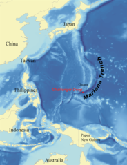
This is a picture of what it looks like from a satellite perspective.
摘要
| 描述 |
English: Map showing the location of the Mariana Trench, designed as a replacement for en:Image:Mariana_trench_location.jpg. Français : Carte montrant la position de la fosse des Mariannes.
Latina: Haec charta locum Fossae Marianae demonstrat. |
| 日期 | |
| 來源 | self-made using data from NOAA[dead link]. |
| 作者 | wallace |
協議
I, Kmusser, the copyright holder of this work, hereby publishes it under the following licenses:

|
根據自由軟體基金會發佈嘅無固定段落、封面文字同封底文字GNU自由文件授權條款第1.2或打後嘅版本,你獲授權可以重製、散佈同埋修改爾份文件。授權條款嘅副本喺章節GNU自由文件授權條款。 |
| 呢個檔案用共享創意 姓名標示-非商業性-相同方式分享3.0 未本地化版本條款授權。 | ||
| 姓名標示: I, Kmusser | ||
| ||
| This licensing tag was added to this file as part of the GFDL licensing update. |
Ĉi tiu dosiero estas disponebla laŭ la permesilo Krea Komunaĵo Atribuite 2.5 Ĝenerala.
姓名標示: I, Kmusser
- 你可以:
- 去分享 – 複製、發佈同傳播呢個作品
- 再改 – 創作演繹作品
- 要遵照下面嘅條件:
- 署名 – 你一定要畀合適嘅表彰、畀返指向呢個授權條款嘅連結,同埋寫明有無改過嚟。你可以用任何合理方式去做,但唔可以用任何方式暗示授權人認可咗你或者你嘅使用方式。
你可以揀你想用嘅牌照。
檔案歷史
撳個日期/時間去睇響嗰個時間出現過嘅檔案。
| 日期/時間 | 縮圖 | 尺寸 | 用戶 | 註解 | |
|---|---|---|---|---|---|
| 現時 | 2020年6月14號 (日) 21:39 | | 756 × 984(758 KB) | Roy17 | lossless crop from 2007 original, then annotated |
| 2016年6月2號 (四) 08:43 |  | 756 × 985(604 KB) | McGeddon | Cropped 1 % horizontally and < 1 % vertically using CropTool with precise mode. Crop out 1px black border. | |
| 2008年1月8號 (二) 06:09 |  | 761 × 989(598 KB) | Lee Carre | File size efficiency, reduced my 50KB without loss of image data. | |
| 2007年8月2號 (四) 15:26 |  | 773 × 1,000(658 KB) | Kmusser | {{Information |Description=Map showing the location of the Mariana Trench, designed as a replacement for en:Image:Mariana_trench_location.jpg. |Source=self-made using [http://www.ngdc.noaa.gov/seg/fliers/se-1104.shtml|data from |
檔案用途
以下嘅1版用到呢個檔:
全域檔案使用情況
下面嘅維基都用緊呢個檔案:
- af.wikipedia.org嘅使用情況
- ar.wikipedia.org嘅使用情況
- ary.wikipedia.org嘅使用情況
- ast.wikipedia.org嘅使用情況
- azb.wikipedia.org嘅使用情況
- az.wikipedia.org嘅使用情況
- ba.wikipedia.org嘅使用情況
- be-tarask.wikipedia.org嘅使用情況
- be.wikipedia.org嘅使用情況
- bg.wikipedia.org嘅使用情況
- bn.wikipedia.org嘅使用情況
- br.wikipedia.org嘅使用情況
- bs.wikipedia.org嘅使用情況
- ca.wikipedia.org嘅使用情況
- ceb.wikipedia.org嘅使用情況
- ce.wikipedia.org嘅使用情況
- ckb.wikipedia.org嘅使用情況
- cs.wikipedia.org嘅使用情況
- da.wikipedia.org嘅使用情況
- el.wikipedia.org嘅使用情況
- en.wikipedia.org嘅使用情況
- Challenger Deep
- Mariana Trench
- Abyssal plain
- Kaikō ROV
- User:Kmusser/Images
- Portal:Geology
- Nereus (underwater vehicle)
- Marianas Trench Marine National Monument
- Deep-sea community
- Wikipedia:ITN archives/2009/June
- User:DiverDave/Deep sea communities
- List of submarine topographical features
- User:سائغ/T
- Hadal zone microbial communities
- en.wikibooks.org嘅使用情況
- en.wikinews.org嘅使用情況
- eo.wikipedia.org嘅使用情況
- es.wikipedia.org嘅使用情況
睇呢個檔案嘅更多全域使用情況。