File:Mughal Empire (orthographic projection).svg

呢個「SVG」檔案嘅呢個「PNG」預覽嘅大細:541 × 541 像素。 第啲解像度:240 × 240 像素|480 × 480 像素|768 × 768 像素|1,024 × 1,024 像素|2,048 × 2,048 像素。
原本檔案 (SVG檔案,表面大細: 541 × 541 像素,檔案大細:217 KB)

.svg?uselang=yue)
摘要
| 描述 |
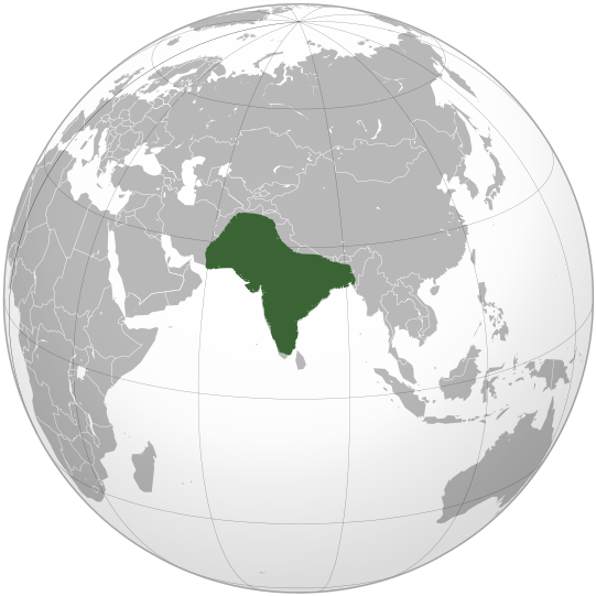
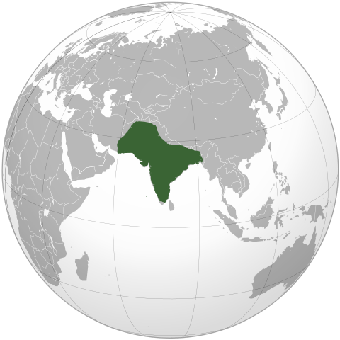
English: Location of Mughal Empire in the reign of Aurangzeb. |
| 日期 | |
| 來源 | 自己作品 |
| 作者 | KarnRedsun |
協議
I, the copyright holder of this work, hereby publish it under the following licenses:
呢個檔案用共享創意 姓名標示-非商業性-相同方式分享3.0 未本地化版本條款授權。
- 你可以:
- 去分享 – 複製、發佈同傳播呢個作品
- 再改 – 創作演繹作品
- 要遵照下面嘅條件:
- 署名 – 你一定要畀合適嘅表彰、畀返指向呢個授權條款嘅連結,同埋寫明有無改過嚟。你可以用任何合理方式去做,但唔可以用任何方式暗示授權人認可咗你或者你嘅使用方式。
- 相同方式分享 – 如果你用任何方式改過呢個作品,你必須要用返原本或者相似嘅條款發佈。

|
根據自由軟體基金會發佈嘅無固定段落、封面文字同封底文字GNU自由文件授權條款第1.2或打後嘅版本,你獲授權可以重製、散佈同埋修改爾份文件。授權條款嘅副本喺章節GNU自由文件授權條款。 |
你可以揀你想用嘅牌照。
檔案歷史
撳個日期/時間去睇響嗰個時間出現過嘅檔案。
| 日期/時間 | 縮圖 | 尺寸 | 用戶 | 註解 | |
|---|---|---|---|---|---|
| 現時 | 2019年12月19號 (四) 16:29 | | 541 × 541(217 KB) | Goran tek-en | Added border for South Sudan as requested by {{u|Maphobbyist}} |
| 2009年10月17號 (六) 09:11 |  | 541 × 541(552 KB) | KarnRedsun | {{Information |Description={{en|1=Location of Mughal Empire in the reign of Aurangzeb.}} |Source={{own}} |Author=KarnRedsun |Date=2009-10-17 |Permission= |other_versions= }} Category:SVG - Orthographic projections [[Category:Maps |
檔案用途
無嘢連來呢份檔案。
全域檔案使用情況
下面嘅維基都用緊呢個檔案:
- ckb.wikipedia.org嘅使用情況
- el.wikipedia.org嘅使用情況
- en.wikipedia.org嘅使用情況
- es.wikipedia.org嘅使用情況
- fa.wikipedia.org嘅使用情況
- fr.wikipedia.org嘅使用情況
- he.wikipedia.org嘅使用情況
- id.wikipedia.org嘅使用情況
- it.wikipedia.org嘅使用情況
- it.wikivoyage.org嘅使用情況
- ja.wikipedia.org嘅使用情況
- jv.wikipedia.org嘅使用情況
- ko.wikipedia.org嘅使用情況
- ky.wikipedia.org嘅使用情況
- mg.wikipedia.org嘅使用情況
- ru.wikipedia.org嘅使用情況
- sco.wikipedia.org嘅使用情況
- tr.wikipedia.org嘅使用情況
- vi.wikipedia.org嘅使用情況
.svg)