File:Red Sea topographic map-en.jpg
原本檔案 (1,655 × 2,705 像素,檔案大細:1.63 MB ,MIME類型:image/jpeg)
摘要
| Camera location | | View this and other nearby images on: OpenStreetMap |
|---|
| 描述 |
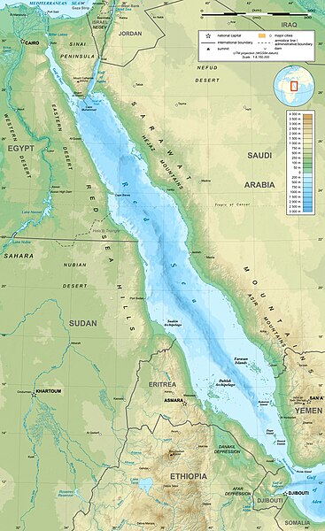
English: Topographic map in English of the Red Sea, UTM projection (WGS84 datum).
Note : for translation purpose, use the SVG version. Français : Carte topographique en anglais de la Mer Rouge, projection UTM (WGS84 datum).
|
||
| 日期 | |||
| 來源 | Own work (see complete description on Image:Red_Sea_topographic_map-en.svg) | ||
| 作者 | Eric Gaba (Sting - fr:Sting) | ||
| 許可 (重用呢個檔案) |
|
||
| Other versions |
[]
|


協議
I, the copyright holder of this work, hereby publish it under the following licenses:

|
根據自由軟體基金會發佈嘅無固定段落、封面文字同封底文字GNU自由文件授權條款第1.2或打後嘅版本,你獲授權可以重製、散佈同埋修改爾份文件。授權條款嘅副本喺章節GNU自由文件授權條款。 |
This file is licensed under the Creative Commons Attribution-Share Alike 4.0 International, 3.0 Unported, 2.5 Generic, 2.0 Generic and 1.0 Generic license.
- 你可以:
- 去分享 – 複製、發佈同傳播呢個作品
- 再改 – 創作演繹作品
- 要遵照下面嘅條件:
- 署名 – 你一定要畀合適嘅表彰、畀返指向呢個授權條款嘅連結,同埋寫明有無改過嚟。你可以用任何合理方式去做,但唔可以用任何方式暗示授權人認可咗你或者你嘅使用方式。
- 相同方式分享 – 如果你用任何方式改過呢個作品,你必須要用返原本或者相似嘅條款發佈。
你可以揀你想用嘅牌照。
檔案歷史
撳個日期/時間去睇響嗰個時間出現過嘅檔案。
| 日期/時間 | 縮圖 | 尺寸 | 用戶 | 註解 | |
|---|---|---|---|---|---|
| 現時 | 2023年12月29號 (五) 15:40 |  | 1,655 × 2,705(1.63 MB) | Sting | Without frame |
| 2010年7月19號 (一) 13:37 |  | 1,655 × 2,705(1.68 MB) | Sting | Color profile | |
| 2008年9月2號 (二) 04:47 |  | 1,655 × 2,705(1.6 MB) | Sting | New standard colors ; bathymetry from ETOPO1 ; etc. | |
| 2008年4月3號 (四) 19:35 |  | 1,655 × 2,705(1.67 MB) | Sting | Additional corrections | |
| 2008年4月3號 (四) 13:09 |  | 1,655 × 2,705(1.71 MB) | Sting | Some names corrections ; some improvements | |
| 2008年4月3號 (四) 11:26 |  | 1,655 × 2,705(1.67 MB) | Sting | Little correction | |
| 2008年4月2號 (三) 22:32 |  | 1,655 × 2,705(1.7 MB) | Sting | {{Location|21|00|00|N|38|00|00|E|scale:10000000}} <br/> {{Information |Description={{en|Topographic map in English of the red Sea<br/>''Note :'' for translation purpose, use the SVG version.}} {{fr |
檔案用途
以下嘅1版用到呢個檔:
全域檔案使用情況
下面嘅維基都用緊呢個檔案:
- ami.wikipedia.org嘅使用情況
- am.wikipedia.org嘅使用情況
- ban.wikipedia.org嘅使用情況
- bg.wikipedia.org嘅使用情況
- bh.wikipedia.org嘅使用情況
- bn.wikipedia.org嘅使用情況
- ca.wikipedia.org嘅使用情況
- ckb.wikipedia.org嘅使用情況
- en.wikipedia.org嘅使用情況
- eu.wikipedia.org嘅使用情況
- fa.wikipedia.org嘅使用情況
- fa.wikivoyage.org嘅使用情況
- gu.wikipedia.org嘅使用情況
- hak.wikipedia.org嘅使用情況
- he.wikipedia.org嘅使用情況
- he.wiktionary.org嘅使用情況
- hi.wikipedia.org嘅使用情況
- hr.wikipedia.org嘅使用情況
- ilo.wikipedia.org嘅使用情況
- incubator.wikimedia.org嘅使用情況
- ja.wikipedia.org嘅使用情況
- ja.wikibooks.org嘅使用情況
- ka.wikipedia.org嘅使用情況
- kcg.wikipedia.org嘅使用情況
- kn.wikipedia.org嘅使用情況
- ko.wikipedia.org嘅使用情況
- lfn.wikipedia.org嘅使用情況
- lv.wikipedia.org嘅使用情況
- mai.wikipedia.org嘅使用情況
- ml.wikipedia.org嘅使用情況
- ms.wikipedia.org嘅使用情況
- my.wikipedia.org嘅使用情況
- ne.wikipedia.org嘅使用情況
- no.wikipedia.org嘅使用情況
- olo.wikipedia.org嘅使用情況
睇呢個檔案嘅更多全域使用情況。