File:Senkaku Diaoyu Tiaoyu Islands.png
預覽大細:600 × 600 像素。 第啲解像度:240 × 240 像素|480 × 480 像素|900 × 900 像素。
原本檔案 (900 × 900 像素,檔案大細:284 KB ,MIME類型:image/png)
摘要
| 描述 |
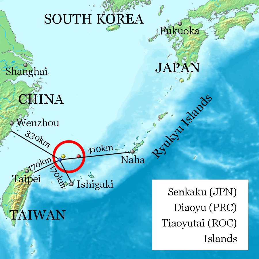
English: Uotsuri-shima / Diaoyu Dao (Blue, west end and nearly south end, 25°44′33″N 123°28′17″E at Mount Narahara), Kuba-shima / Huangwei Yu (Yellow, north end, 25°55′24″N 123°40′51″E at Mount Chitose), Taishō-tō / Chiwei Yu (Red, east end, 25°55′21″N 124°33′36″E at the peek) referenced on Geospatial Information Authority of Japan and distances referenced on Ministry of Foreign Affairs of Japan. Every distances of the map show coast to coast, but distances of the coast of Okinawa Island and Naha City, and the coast of Ishigaki-Island and Ishigaki City are quite near on the map. |
| 日期 | |
| 來源 | image:Topographic15deg_N20E120.png |
| 作者 | Jackopoid |

|
This map image could be recreated using vector graphics as an SVG file. This has several advantages; see Commons:Media for cleanup for more information. If an SVG form of this image is already available, please upload it. After uploading an SVG, replace this template with {{vector version available|new image name.svg}}.
|
協議

|
根據自由軟體基金會發佈嘅無固定段落、封面文字同封底文字GNU自由文件授權條款第1.2或打後嘅版本,你獲授權可以重製、散佈同埋修改爾份文件。授權條款嘅副本喺章節GNU自由文件授權條款。 |
| 呢個檔案用共享創意 姓名標示-非商業性-相同方式分享3.0 未本地化版本條款授權。 | ||
| ||
| This licensing tag was added to this file as part of the GFDL licensing update. |
檔案歷史
撳個日期/時間去睇響嗰個時間出現過嘅檔案。
| 日期/時間 | 縮圖 | 尺寸 | 用戶 | 註解 | |
|---|---|---|---|---|---|
| 現時 | 2013年2月20號 (三) 17:31 | | 900 × 900(284 KB) | ジャコウネズミ | Diaoyutai (PRC) --> Diaoyu (PRC) |
| 2013年2月13號 (三) 02:04 |  | 900 × 900(284 KB) | ジャコウネズミ | Correct location | |
| 2013年2月12號 (二) 19:09 |  | 900 × 900(284 KB) | ジャコウネズミ | User created page with UploadWizard |
檔案用途
以下嘅1版用到呢個檔:
全域檔案使用情況
下面嘅維基都用緊呢個檔案:
- af.wikipedia.org嘅使用情況
- ar.wikipedia.org嘅使用情況
- bg.wikipedia.org嘅使用情況
- bn.wikipedia.org嘅使用情況
- cdo.wikipedia.org嘅使用情況
- cs.wikipedia.org嘅使用情況
- cy.wikipedia.org嘅使用情況
- da.wikipedia.org嘅使用情況
- de.wikipedia.org嘅使用情況
- en.wikipedia.org嘅使用情況
- es.wikipedia.org嘅使用情況
- fa.wikipedia.org嘅使用情況
- gl.wikipedia.org嘅使用情況
- he.wikipedia.org嘅使用情況
- id.wikipedia.org嘅使用情況
- it.wikipedia.org嘅使用情況
- ja.wikipedia.org嘅使用情況
- ko.wikipedia.org嘅使用情況
- mn.wikipedia.org嘅使用情況
- ms.wikipedia.org嘅使用情況
- nl.wikipedia.org嘅使用情況
- nn.wikipedia.org嘅使用情況
- no.wikipedia.org嘅使用情況
- pl.wikipedia.org嘅使用情況
- pt.wikipedia.org嘅使用情況
- ro.wikipedia.org嘅使用情況
- ru.wikipedia.org嘅使用情況
- sco.wikipedia.org嘅使用情況
- sr.wikipedia.org嘅使用情況
- sv.wikipedia.org嘅使用情況
- th.wikipedia.org嘅使用情況
- tr.wikipedia.org嘅使用情況
- ur.wikipedia.org嘅使用情況
- vi.wikipedia.org嘅使用情況
睇呢個檔案嘅更多全域使用情況。