File:Sub-Saharan Africa definition UN.png
冇更高解像度嘅圖像。
Sub-Saharan_Africa_definition_UN.png (362 × 340 像素,檔案大細:6 KB ,MIME類型:image/png)

|
This map image could be recreated using vector graphics as an SVG file. This has several advantages; see Commons:Media for cleanup for more information. If an SVG form of this image is already available, please upload it. After uploading an SVG, replace this template with {{vector version available|new image name.svg}}.
|
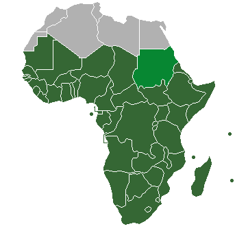
| 描述 |
Definition of "Sub-Saharan Africa" as used in the statistics of many the UN institutions. Sudan is also classified as North Africa by the United Nations. |
| 日期 | (UTC) |
| 來源 | |
| 作者 |
| This is a retouched picture, which means that it has been digitally altered from its original version. Modifications: binary colouring of countries. The original can be viewed here: HDImap spectrum2006 Africa.png:
|
我,呢份作品嘅作者,決定用以下許可發佈呢件作品:
| I, the copyright holder of this work, release this work into the public domain. This applies worldwide. In some countries this may not be legally possible; if so: I grant anyone the right to use this work for any purpose, without any conditions, unless such conditions are required by law. |
Original upload log
This image is a derivative work of the following images:
- File:HDImap_spectrum2006_Africa.png licensed with PD-self
- 2007-03-09T10:43:40Z Dbachmann 356x344 (7521 Bytes) == Summary == Detail of [[:Image:HDImap spectrum2006.png]]. [[:en:United Natiows|UN]] [[:en:Human Development Index|Human Development Index (HDI)]] for 2004, derived from 2006 UN HDI report. An HDI below 0.5 is considered to
Uploaded with derivativeFX
檔案歷史
撳個日期/時間去睇響嗰個時間出現過嘅檔案。
| 日期/時間 | 縮圖 | 尺寸 | 用戶 | 註解 | |
|---|---|---|---|---|---|
| 現時 | 2013年7月19號 (五) 20:47 | | 362 × 340(6 KB) | Maproom | Reshaded South Sudan, which the UN now regards as in East Africa, not North Africa: see http://unstats.un.org/unsd/methods/m49/m49regin.htm |
| 2012年4月12號 (四) 13:27 |  | 362 × 340(9 KB) | Hazhk | Adding different shading for Sudan & S. Sudan because they're also classified as being part of North Africa by the UN | |
| 2011年7月9號 (六) 22:02 |  | 356 × 344(11 KB) | Maphobbyist | South Sudan has become independent on July 9, 2011. Sudan and South Sudan are shown with the new international border between them. | |
| 2011年3月31號 (四) 06:46 |  | 356 × 344(10 KB) | Hoshie | added Cabinda (Angola) to map | |
| 2010年12月15號 (三) 11:18 |  | 356 × 344(6 KB) | Jcherlet | {{Information |Description=Definition of Sub-Saharan Africa, according to the United Nations institutions |Source=*File:HDImap_spectrum2006_Africa.png |Date=2010-12-15 11:13 (UTC) |Author=*Jcherlet: '''Jcherlet''' *derivative work: |
檔案用途
以下嘅1版用到呢個檔:
全域檔案使用情況
下面嘅維基都用緊呢個檔案:
- ast.wikipedia.org嘅使用情況
- ca.wikipedia.org嘅使用情況
- ckb.wikipedia.org嘅使用情況
- cs.wikipedia.org嘅使用情況
- de.wikipedia.org嘅使用情況
- en.wikipedia.org嘅使用情況
- Sub-Saharan Africa
- Water supply and sanitation in sub-Saharan Africa
- Wikipedia:Reference desk/Archives/Humanities/2013 October 5
- Category:Birds of Sub-Saharan Africa
- Category:Fauna of Sub-Saharan Africa
- Category:Biota of Sub-Saharan Africa
- Category:Mammals of Sub-Saharan Africa
- User:DexDor/Categorization of organisms by geography
- Category:Moths of Sub-Saharan Africa
- Category:Amphibians of Sub-Saharan Africa
- et.wikipedia.org嘅使用情況
- ha.wikipedia.org嘅使用情況
- he.wikipedia.org嘅使用情況
- id.wikipedia.org嘅使用情況
- ig.wikipedia.org嘅使用情況
- ilo.wikipedia.org嘅使用情況
- it.wikipedia.org嘅使用情況
- ja.wikipedia.org嘅使用情況
- ka.wikipedia.org嘅使用情況
- ko.wikipedia.org嘅使用情況
- lt.wikipedia.org嘅使用情況
- pa.wikipedia.org嘅使用情況
- pnb.wikipedia.org嘅使用情況
- ro.wikipedia.org嘅使用情況
- simple.wikipedia.org嘅使用情況
- sr.wikipedia.org嘅使用情況
- sv.wikipedia.org嘅使用情況
- ta.wikipedia.org嘅使用情況
- th.wikipedia.org嘅使用情況
- tn.wikipedia.org嘅使用情況
- tr.wikipedia.org嘅使用情況
睇呢個檔案嘅更多全域使用情況。