File:Sunda strait map v4.png
冇更高解像度嘅圖像。
Sunda_strait_map_v4.png (487 × 351 像素,檔案大細:176 KB ,MIME類型:image/png)
摘要
| 描述 |
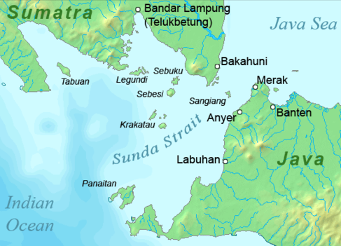
Deutsch: Karte der Sundastraße, Indonesien
English: Map of the Sunda Strait, Indonesia |
||||
| 日期 | |||||
| 來源 | 自己作品 | ||||
| 作者 | Telim tor | ||||
| 許可 (重用呢個檔案) |
|
||||
| Other versions |

檔案歷史
撳個日期/時間去睇響嗰個時間出現過嘅檔案。
| 日期/時間 | 縮圖 | 尺寸 | 用戶 | 註解 | |
|---|---|---|---|---|---|
| 現時 | 2011年1月23號 (日) 11:37 | | 487 × 351(176 KB) | Telim tor | == {{int:filedesc}} == {{Information |Description={{en|Map of the Sunda Strait, Indonesia}} |Source={{own}} |Date=2011-01-23 |Author=Telim tor |Permission={{PD-Demis}} |other_versions=={{Extracted from|Sunda_strait_map_v3.png}} }} [[Ca |
檔案用途
以下嘅1版用到呢個檔:
全域檔案使用情況
下面嘅維基都用緊呢個檔案:
- ar.wikipedia.org嘅使用情況
- de.wikipedia.org嘅使用情況
- en.wikipedia.org嘅使用情況
- id.wikipedia.org嘅使用情況
- it.wikipedia.org嘅使用情況
- ka.wikipedia.org嘅使用情況
- nl.wikipedia.org嘅使用情況
- no.wikipedia.org嘅使用情況
- sh.wikipedia.org嘅使用情況
- uk.wikipedia.org嘅使用情況