File:TahitiMooreaMap.png

預覽大細:800 × 598 像素。 第啲解像度:320 × 239 像素|640 × 479 像素|979 × 732 像素。
原本檔案 (979 × 732 像素,檔案大細:16 KB ,MIME類型:image/png)
摘要
| 描述 |
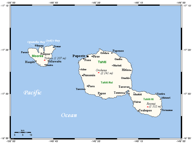
English: A map of Tahiti and Moorea in the Society Islands (French Polynesia) showing main centres and peaks |
| 日期 | not specified |
| 來源 | This map's source is here (select Papeete in the search box), with the uploader's modifications, and the GMT homepage says that the tools are released under the GNU General Public License |
| 作者 | Kelisi at en.wikipedia |

|
This map image could be recreated using vector graphics as an SVG file. This has several advantages; see Commons:Media for cleanup for more information. If an SVG form of this image is already available, please upload it. After uploading an SVG, replace this template with {{vector version available|new image name.svg}}.
|
協議
Kelisi from en.wikipedia.org, the copyright holder of this work, hereby publishes it under the following license:
| 呢個檔案用共享創意 姓名標示-非商業性-相同方式分享3.0 未本地化版本條款授權。 Subject to disclaimers. | ||
| 姓名標示: Kelisi from en.wikipedia.org | ||
| ||
| This licensing tag was added to this file as part of the GFDL licensing update. |

|
根據自由軟體基金會發佈嘅無固定段落、封面文字同封底文字GNU自由文件授權條款第1.2或打後嘅版本,你獲授權可以重製、散佈同埋修改爾份文件。授權條款嘅副本喺章節GNU自由文件授權條款。 Subject to disclaimers. |
Original upload log
All following user names refer to en.wikipedia.
- 2006-04-22 16:30 Kelisi 972×732×8 (16 KB) (Map of Tahiti and Moorea showing main centres, peaks. This map's source is [http://www.aquarius.geomar.de/omc/make_map.html here], with the uploader's modifications, and the [http://gmt.soest.hawaii.edu/ GMT homepage] says that the tools are released unde)
檔案歷史
撳個日期/時間去睇響嗰個時間出現過嘅檔案。
| 日期/時間 | 縮圖 | 尺寸 | 用戶 | 註解 | |
|---|---|---|---|---|---|
| 現時 | 2009年2月11號 (三) 08:47 | | 979 × 732(16 KB) | Telim tor | == Information == {{Information |Description={{en|A map of Tahiti and Moorea in the Society Islands, French Polynesia}} |Source=This map's source is [http://www.aquarius.ifm-geomar.de/ here], with the uploader's modifications, and the [http://gmt.soest.ha |
檔案用途
以下嘅1版用到呢個檔:
全域檔案使用情況
下面嘅維基都用緊呢個檔案:
- af.wikipedia.org嘅使用情況
- en.wikipedia.org嘅使用情況
- es.wikipedia.org嘅使用情況
- fa.wikipedia.org嘅使用情況
- fi.wikipedia.org嘅使用情況
- fr.wikipedia.org嘅使用情況
- gl.wikipedia.org嘅使用情況
- hu.wikipedia.org嘅使用情況
- id.wikipedia.org嘅使用情況
- it.wikipedia.org嘅使用情況
- ja.wikipedia.org嘅使用情況
- ka.wikipedia.org嘅使用情況
- kn.wikipedia.org嘅使用情況
- lt.wikipedia.org嘅使用情況
- mk.wikipedia.org嘅使用情況
- nl.wikipedia.org嘅使用情況
- no.wikipedia.org嘅使用情況
- pl.wikivoyage.org嘅使用情況
- pt.wikipedia.org嘅使用情況
- ro.wikipedia.org嘅使用情況
- ru.wikipedia.org嘅使用情況
- ty.wikipedia.org嘅使用情況
- uk.wikipedia.org嘅使用情況
- xmf.wikipedia.org嘅使用情況
- zh.wikipedia.org嘅使用情況