File:Tectonic plates (empty).svg

呢個「SVG」檔案嘅呢個「PNG」預覽嘅大細:681 × 461 像素。 第啲解像度:320 × 217 像素|640 × 433 像素|1,024 × 693 像素|1,280 × 866 像素|2,560 × 1,733 像素。
原本檔案 (SVG檔案,表面大細: 681 × 461 像素,檔案大細:356 KB)
الخلافه الرشيديهkp
摘要
| 描述 | |
| 日期 | 2005年9月10號 (upload date) |
| 來源 | File:Tectonic plates (empty).png |
| 作者 | Ævar Arnfjörð Bjarmason |
| Other versions |
This file was derived from: Tectonic plates (empty).png:
[]
|
| SVG genesis | This W3C-invalid map was created with Adobe Illustrator, and with Inkscape. |


.png)


.svg?uselang=yue)
.png)
協議
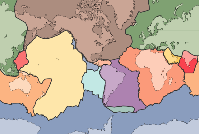
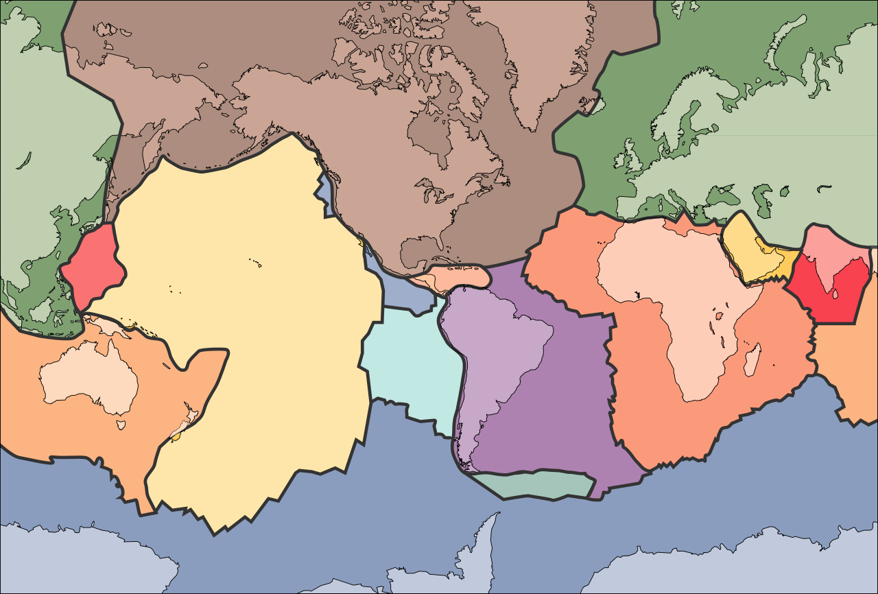
This image is in the public domain in the United States because it only contains materials that originally came from the United States Geological Survey, an agency of the United States Department of the Interior. For more information, see the official USGS copyright policy.
|
檔案歷史
撳個日期/時間去睇響嗰個時間出現過嘅檔案。
| 日期/時間 | 縮圖 | 尺寸 | 用戶 | 註解 | |
|---|---|---|---|---|---|
| 現時 | 2006年10月11號 (三) 02:04 | | 681 × 461(356 KB) | Sting | Borders correction integrated to the continents borders; size of picture |
| 2006年10月10號 (二) 16:29 |  | 682 × 462(285 KB) | Rogilbert~commonswiki | correction de frontières 2 | |
| 2006年10月10號 (二) 16:14 |  | 682 × 462(212 KB) | Rogilbert~commonswiki | correction des frontière | |
| 2005年9月10號 (六) 13:48 |  | 682 × 462(199 KB) | Ævar Arnfjörð Bjarmason | SVG version of Image:Tectonic plates (empty).png {{PD-USGov-USGS}} Category:Plate tectonics |
.png)
檔案用途
全域檔案使用情況
下面嘅維基都用緊呢個檔案:
- ar.wikipedia.org嘅使用情況
- az.wikipedia.org嘅使用情況
- bn.wikipedia.org嘅使用情況
- en.wikipedia.org嘅使用情況
- Earth
- Internal structure of Earth
- Wikipedia:Graphics Lab/Image workshop/Archive/Jan 2009
- User:AvionArchon/sandbox
- User:Darth Tacker/TWA/Earth
- User:CheChe/Spoken Script
- User:Zanygenius/TWA/Earth
- User:Zanygenius/TWA/Earth/2
- User:Google7722/TWA/Earth
- Portal:Geophysics
- Portal:World
- User:FreshYoMama/TWA/Earth
- User:FreshYoMama/TWA/Earth/2
- en.wikiversity.org嘅使用情況
- eo.wikipedia.org嘅使用情況
- Kontinento
- Platotektoniko
- Litosfero
- Tektona plato
- Ŝablono:Tektonaj platoj
- Antarkta plato
- Eŭrazia plato
- Nordamerika plato
- Sudamerika plato
- Afrika plato
- Pacifika plato
- Hindia plato
- Aŭstralia plato
- Plato Nazca
- Anatolia plato
- Arabia plato
- Filipina plato
- Kokosa plato
- Karibia plato
- Plato Juan de Fuca
- Hind-Aŭstralia Plato
- es.wikipedia.org嘅使用情況
- fa.wikipedia.org嘅使用情況
- fr.wikipedia.org嘅使用情況
- gl.wikipedia.org嘅使用情況
- hu.wikipedia.org嘅使用情況
- id.wikipedia.org嘅使用情況
- io.wikipedia.org嘅使用情況
睇呢個檔案嘅更多全域使用情況。
.svg)
.svg)