File:Tokara-eilanden.png
冇更高解像度嘅圖像。
Tokara-eilanden.png (419 × 175 像素,檔案大細:4 KB ,MIME類型:image/png)
摘要
| 描述 |
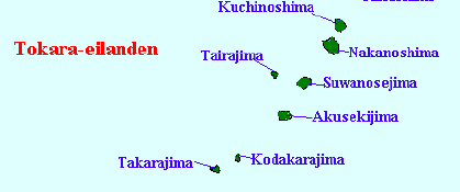
English: Map of the Tokara Islands, Kagoshima Prefecture, Japan |
||
| 日期 | (UTC) | ||
| 來源 | |||
| 作者 |
|
||
| Other versions |
|

| This is a retouched picture, which means that it has been digitally altered from its original version. The original can be viewed here: Satsunan Islands.png:
|
協議
我,呢份作品嘅作者,決定用以下許可發佈呢件作品:
| I, the copyright holder of this work, release this work into the public domain. This applies worldwide. In some countries this may not be legally possible; if so: I grant anyone the right to use this work for any purpose, without any conditions, unless such conditions are required by law. |
Original upload log
This image is a derivative work of the following images:
- File:Satsunan_Islands.png licensed with PD-self
- 2007-01-05T16:16:30Z Krisgrotius 780x1083 (77720 Bytes) {{Information |Description=Map of the Satsunan Islands (Ōsumi Islands + Tokara Islands + Amami Islands), Ryukyu , Japan |Source= own work |Date=~~~~~ |Author=~~~ |Permission= |other_versions= public }}
Uploaded with derivativeFX
檔案歷史
撳個日期/時間去睇響嗰個時間出現過嘅檔案。
| 日期/時間 | 縮圖 | 尺寸 | 用戶 | 註解 | |
|---|---|---|---|---|---|
| 現時 | 2009年3月1號 (日) 18:55 | | 419 × 175(4 KB) | A1000 | {{Information |Description=Map of the Satsunan Islands (Ōsumi Islands + Tokara Islands + Amami Islands), Ryukyu , Japan |Source=*File:Satsunan_Islands.png |Date=2009-03-01 18:54 (UTC) |Author=*File:Satsunan_Islands.png: [[User:Krisgrotius|Kri |
檔案用途
以下嘅1版用到呢個檔:
全域檔案使用情況
下面嘅維基都用緊呢個檔案:
- arz.wikipedia.org嘅使用情況
- cs.wikipedia.org嘅使用情況
- de.wikipedia.org嘅使用情況
- en.wikipedia.org嘅使用情況
- es.wikipedia.org嘅使用情況
- fr.wikipedia.org嘅使用情況
- ml.wikipedia.org嘅使用情況
- mr.wikipedia.org嘅使用情況
- no.wikipedia.org嘅使用情況
- pl.wikipedia.org嘅使用情況
- uk.wikipedia.org嘅使用情況
- www.wikidata.org嘅使用情況
- zh-min-nan.wikipedia.org嘅使用情況
- zh.wikipedia.org嘅使用情況