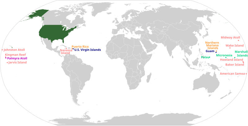
File:US insular areas.svg

呢個「SVG」檔案嘅呢個「PNG」預覽嘅大細:800 × 406 像素。 第啲解像度:320 × 162 像素|640 × 325 像素|1,024 × 520 像素|1,280 × 650 像素|2,560 × 1,300 像素|2,754 × 1,398 像素。
原本檔案 (SVG檔案,表面大細: 2,754 × 1,398 像素,檔案大細:1.06 MB)
檔案歷史
撳個日期/時間去睇響嗰個時間出現過嘅檔案。
| 日期/時間 | 縮圖 | 尺寸 | 用戶 | 註解 | |
|---|---|---|---|---|---|
| 現時 | 2023年10月6號 (五) 14:48 |  | 2,754 × 1,398(1.06 MB) | LametinoWiki | File uploaded using svgtranslate tool (https://svgtranslate.toolforge.org/). Added translation for eu. |
| 2023年5月29號 (一) 18:37 |  | 2,754 × 1,398(1.06 MB) | Aspere | File uploaded using svgtranslate tool (https://svgtranslate.toolforge.org/). Added translation for ko. | |
| 2023年5月24號 (三) 05:42 |  | 2,754 × 1,398(1.06 MB) | Illchy | File uploaded using svgtranslate tool (https://svgtranslate.toolforge.org/). Added translation for id. | |
| 2020年7月6號 (一) 14:14 |  | 2,754 × 1,398(1.06 MB) | Heitordp | Adjusted text alignment | |
| 2020年7月6號 (一) 13:47 |  | 2,754 × 1,398(1.05 MB) | Heitordp | Corrected locations | |
| 2020年5月5號 (二) 17:59 |  | 512 × 263(1.5 MB) | Pharexia | improved readability of territories–added white background for visibility, minor color modification to align with USA locator map | |
| 2020年1月28號 (二) 23:14 |  | 1,474 × 628(679 KB) | JoKalliauer | Repaired file of 10:12, 5. Jan. 2020; phab:T217990, do not use SVGOMG on foreign files, see c:User:JoKalliauer/Optimization; please use Commons:Commons_SVG_Checker and File:Test.svg before uploading | |
| 2020年1月5號 (日) 22:13 |  | 1,474 × 628(1.94 MB) | AndreyKva | Reverted to version as of 20:30, 5 January 2020 (UTC). Still appears to be broken. | |
| 2020年1月5號 (日) 22:10 |  | 1,474 × 628(846 KB) | AndreyKva | Second attempt at optimizing with SVGOMG. This time, precision is at a higher setting. I will revert if any issues arise (apologies for the failed upload last time). | |
| 2020年1月5號 (日) 20:30 |  | 1,474 × 628(1.94 MB) | Ahmad252 | Reverted to version as of 09:13, 5 January 2020 (UTC): Still causes rendering problems on all pages the image has been used. |
檔案用途
以下嘅1版用到呢個檔:
全域檔案使用情況
下面嘅維基都用緊呢個檔案:
- af.wikipedia.org嘅使用情況
- ar.wikipedia.org嘅使用情況
- az.wikipedia.org嘅使用情況
- ban.wikipedia.org嘅使用情況
- ba.wikipedia.org嘅使用情況
- bg.wikipedia.org嘅使用情況
- bh.wikipedia.org嘅使用情況
- bjn.wikipedia.org嘅使用情況
- bn.wikipedia.org嘅使用情況
- bs.wikipedia.org嘅使用情況
- ca.wikipedia.org嘅使用情況
- cs.wikipedia.org嘅使用情況
- da.wikipedia.org嘅使用情況
- en.wikipedia.org嘅使用情況
- U.S. territorial sovereignty
- Lists of American universities and colleges
- 51st state
- Historical regions of the United States
- Insular area
- Territories of the United States
- User:Dangerous-Boy
- United States
- User:Buaidh
- Outline of the United States
- Talk:List of largest empires/Archive 2
- Talk:United States/Archive 37
- Talk:List of states and territories of the United States
- User:CaptainElena/sandbox
- User:Buaidh/sandbox
- User:SteveL1990/sandbox
- Template:Portal/doc/all
- User:Getaway Car/vinceroyalty
- User:NiklawskiMSTM/Iodni zad
- User:Garaziarana/Sandbox/Infobox/Country
- User:Callejandrea/Sandbox/Infobox/Country
- User:Estibalizdelgado/sandbox/Infobox/Country
- User:Laura G.Cabriada/sandbox/Infobox/Place
- User:Paul.deprado/Infobox/Country
- User:Paul.deprado/sandbox/Infobox/Country
- User:Paulabente/sandbox/Infobox/Country
- User:Arrate.catarain/Sandbox/Infoboxes/Place
- User:Gorkagomez87/sandbox/Infobox/Country
- Wikipedia:WikiProject United States Territories
- Talk:United States/Archive 81
- User:Stephen100002/sandbox
- User:TheSaint250/sandbox
睇呢個檔案嘅更多全域使用情況。