File:We-map.png

預覽大細:275 × 600 像素。 第啲解像度:110 × 240 像素|326 × 711 像素。
原本檔案 (326 × 711 像素,檔案大細:22 KB ,MIME類型:image/png)
摘要
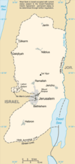
| 描述 |
English: Replacement map of the West Bank from CIA Factbook |
| 來源 | The original GIF image source for this map is: archive copy at the Wayback Machine |
| 作者 | This PNG image was copied from en.wikipedia.org. |
This image is in the public domain because it contains materials that originally came from the United States Central Intelligence Agency's World Factbook.
|
 |
檔案歷史
撳個日期/時間去睇響嗰個時間出現過嘅檔案。
| 日期/時間 | 縮圖 | 尺寸 | 用戶 | 註解 | |
|---|---|---|---|---|---|
| 現時 | 2010年3月25號 (四) 13:56 | | 326 × 711(22 KB) | Ras67 | cropped |
| 2004年9月15號 (三) 12:35 |  | 330 × 715(23 KB) | Robbot | This image was copied from en.wikipedia.org. The original description was: Replacement map of the West Bank from CIA Factbook - public domain en:Image:We-map.png {{PD-USgov}} |
檔案用途
以下嘅1版用到呢個檔:
全域檔案使用情況
下面嘅維基都用緊呢個檔案:
- af.wikipedia.org嘅使用情況
- als.wikipedia.org嘅使用情況
- ar.wikinews.org嘅使用情況
- ast.wikipedia.org嘅使用情況
- be-tarask.wikipedia.org嘅使用情況
- be.wikipedia.org嘅使用情況
- bg.wikipedia.org嘅使用情況
- br.wikipedia.org嘅使用情況
- bs.wikipedia.org嘅使用情況
- ca.wikipedia.org嘅使用情況
- ce.wikipedia.org嘅使用情況
- cs.wikipedia.org嘅使用情況
- cy.wikipedia.org嘅使用情況
- da.wikipedia.org嘅使用情況
- el.wikipedia.org嘅使用情況
- en.wikipedia.org嘅使用情況
- en.wikinews.org嘅使用情況
- eo.wikipedia.org嘅使用情況
- es.wikipedia.org嘅使用情況
- es.wikinews.org嘅使用情況
- et.wikipedia.org嘅使用情況
- fa.wikipedia.org嘅使用情況
- fi.wikipedia.org嘅使用情況
- fi.wiktionary.org嘅使用情況
- fo.wikipedia.org嘅使用情況
- frr.wikipedia.org嘅使用情況
- fr.wikipedia.org嘅使用情況
- fy.wikipedia.org嘅使用情況
- gd.wikipedia.org嘅使用情況
- gn.wikipedia.org嘅使用情況
- gv.wikipedia.org嘅使用情況
- hr.wikipedia.org嘅使用情況
睇呢個檔案嘅更多全域使用情況。