File:2006 North Korean nuclear test.svg

呢個「SVG」檔案嘅呢個「PNG」預覽嘅大細:473 × 408 像素。 第啲解像度:278 × 240 像素|557 × 480 像素|890 × 768 像素|1,187 × 1,024 像素|2,374 × 2,048 像素。
原本檔案 (SVG檔案,表面大細: 473 × 408 像素,檔案大細:71 KB)
摘要
| 描述 |
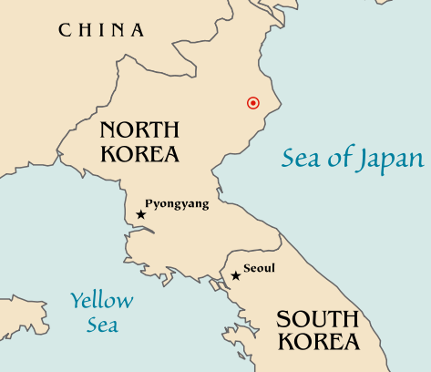
Map of the North Korean nuclear test of October 9, 2006. The red marker indicates the estimated location of the test (41.311°N, 129.114°E). Based off of maps from the CIA World Factbook. |
| 日期 | 2006年10月10號 (original upload date) |
| 來源 | No machine-readable source provided. Own work assumed (based on copyright claims). |
| 作者 | No machine-readable author provided. Mobius assumed (based on copyright claims). |
| Other versions |
|


協議
| I, the copyright holder of this work, release this work into the public domain. This applies worldwide. In some countries this may not be legally possible; if so: I grant anyone the right to use this work for any purpose, without any conditions, unless such conditions are required by law. |
檔案歷史
撳個日期/時間去睇響嗰個時間出現過嘅檔案。
| 日期/時間 | 縮圖 | 尺寸 | 用戶 | 註解 | |
|---|---|---|---|---|---|
| 現時 | 2006年10月10號 (二) 20:48 | | 473 × 408(71 KB) | Mobius | + Crop area, proper license |
| 2006年10月10號 (二) 20:43 |  | 981 × 801(71 KB) | Mobius | Map of the North Korean nuclear test of October 9, 2006. The red marker indicates the estimated location of the test (41.311°N, 129.114°E). Based off of maps from the CIA World Factbook. |
檔案用途
無嘢連來呢份檔案。
全域檔案使用情況
下面嘅維基都用緊呢個檔案:
- ca.wikipedia.org嘅使用情況
- en.wikipedia.org嘅使用情況
- ia.wikipedia.org嘅使用情況
- ko.wikipedia.org嘅使用情況
- nl.wikipedia.org嘅使用情況
- no.wikipedia.org嘅使用情況
- pl.wikinews.org嘅使用情況
- ta.wikinews.org嘅使用情況
- www.wikidata.org嘅使用情況