File:Adyar estuary.jpg

預覽大細:800 × 364 像素。 第啲解像度:320 × 146 像素|640 × 291 像素|1,443 × 657 像素。
原本檔案 (1,443 × 657 像素,檔案大細:249 KB ,MIME類型:image/jpeg)
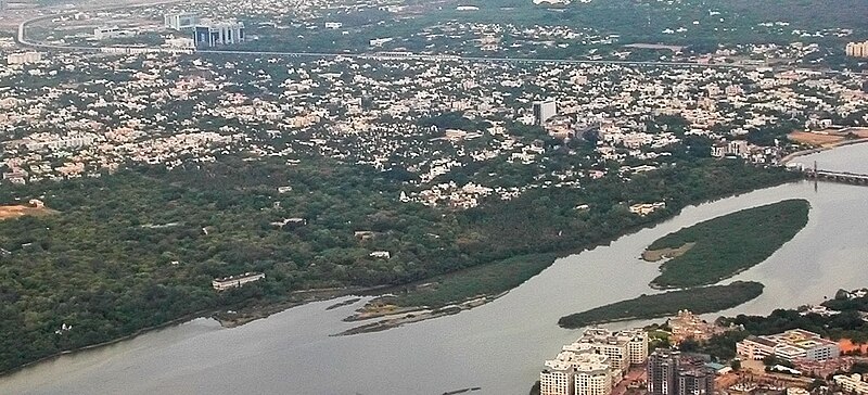
| 描述 | Aerial view of the Adyar Estuary and w:Adyar. On the top ind is w:Tidel Park and the w:Chennai MRTS. The gardens belong to the w:Theosophical Society. | ||
| 日期 | 22 June 05 | ||
| 來源 | 自己作品 | ||
| 作者 |
|
||
| 許可 (重用呢個檔案) |
我,呢份作品嘅作者,決定用以下許可發佈呢件作品: This file is licensed under the Creative Commons Attribution-Share Alike 2.5 Generic license.
|
| Camera location | | View this and other nearby images on: OpenStreetMap |
|---|
檔案歷史
撳個日期/時間去睇響嗰個時間出現過嘅檔案。
| 日期/時間 | 縮圖 | 尺寸 | 用戶 | 註解 | |
|---|---|---|---|---|---|
| 現時 | 2007年4月28號 (六) 12:16 | | 1,443 × 657(249 KB) | Planemad | {{Information |Description=Aerial view of the Adyar Estuary and w:Adyar. On the top ind is w:Tidel Park and the w:Chennai MRTS. |Source=own work |Date= 22 June 05 |Author= w:user:PlaneMad |Permission={{self|cc-by-sa-2.5}} |
檔案用途
以下嘅1版用到呢個檔:
全域檔案使用情況
下面嘅維基都用緊呢個檔案:
- arz.wikipedia.org嘅使用情況
- azb.wikipedia.org嘅使用情況
- bg.wikipedia.org嘅使用情況
- bn.wikipedia.org嘅使用情況
- ceb.wikipedia.org嘅使用情況
- cs.wikipedia.org嘅使用情況
- de.wikipedia.org嘅使用情況
- en.wikipedia.org嘅使用情況
- es.wikipedia.org嘅使用情況
- fa.wikipedia.org嘅使用情況
- fi.wikipedia.org嘅使用情況
- fr.wikipedia.org嘅使用情況
- hi.wikipedia.org嘅使用情況
- id.wikipedia.org嘅使用情況
- incubator.wikimedia.org嘅使用情況
- io.wikipedia.org嘅使用情況
- it.wikipedia.org嘅使用情況
- jv.wikipedia.org嘅使用情況
- ml.wikipedia.org嘅使用情況
- nl.wikipedia.org嘅使用情況
- no.wikipedia.org嘅使用情況
- pt.wikipedia.org嘅使用情況
- ro.wikipedia.org嘅使用情況
- ru.wikipedia.org嘅使用情況
- ta.wikipedia.org嘅使用情況
- uk.wikipedia.org嘅使用情況
- ur.wikipedia.org嘅使用情況
- www.wikidata.org嘅使用情況
- zh-min-nan.wikipedia.org嘅使用情況