File:Antarctica Map.png

預覽大細:488 × 600 像素。 第啲解像度:195 × 240 像素|502 × 617 像素。
原本檔案 (502 × 617 像素,檔案大細:52 KB ,MIME類型:image/png)
- Deutsch: Karte der Antarktis
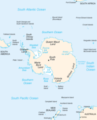
- English: Map of Antarctica
- Español: Mapa de la Antártida
- Polski: Mapa Antarktydy
- For a French version, see : Image:Antarctique_carte.png
- For an German version, see : Image:Antarctica_Karte.png
This image is in the public domain because it contains materials that originally came from the United States Central Intelligence Agency's World Factbook.
|
 |
derivative works
Derivative works of this file: Map-antarctica-ross-ice-shelf-red-x.png
檔案歷史
撳個日期/時間去睇響嗰個時間出現過嘅檔案。
| 日期/時間 | 縮圖 | 尺寸 | 用戶 | 註解 | |
|---|---|---|---|---|---|
| 現時 | 2004年12月15號 (三) 23:16 | | 502 × 617(52 KB) | Mschlindwein |
檔案用途
無嘢連來呢份檔案。
全域檔案使用情況
下面嘅維基都用緊呢個檔案:
- an.wikipedia.org嘅使用情況
- ar.wikipedia.org嘅使用情況
- avk.wikipedia.org嘅使用情況
- azb.wikipedia.org嘅使用情況
- be.wikipedia.org嘅使用情況
- bjn.wikipedia.org嘅使用情況
- blk.wikipedia.org嘅使用情況
- bn.wikipedia.org嘅使用情況
- br.wikipedia.org嘅使用情況
- bs.wikipedia.org嘅使用情況
- ca.wikipedia.org嘅使用情況
- cs.wikipedia.org嘅使用情況
- da.wikipedia.org嘅使用情況
- de.wikinews.org嘅使用情況
- en.wikipedia.org嘅使用情況
- Filchner–Ronne Ice Shelf
- Palmer Land
- Frost Glacier
- Second German Antarctic Expedition
- Totten Glacier
- Wikipedia:WikiProject Antarctica
- Polynesian navigation
- Underwood Glacier
- Farthest South
- Adams Glacier (Wilkes Land)
- Ocean fisheries
- 80th parallel south
- Southern Ocean
- Dibble Iceberg Tongue
- Gilchrist Glacier
- Peterson Glacier
- Bell Glacier
- Blair Glacier
- Blodgett Iceberg Tongue
- Bond Glacier
- Bibliography of Antarctica
- Conger Glacier
- Waldron Glacier
- Whittle Glacier
睇呢個檔案嘅更多全域使用情況。