File:BayofBengalTCNov1219700956UTCITOS1.png
冇更高解像度嘅圖像。
BayofBengalTCNov1219700956UTCITOS1.png (342 × 394 像素,檔案大細:150 KB ,MIME類型:image/png)
摘要
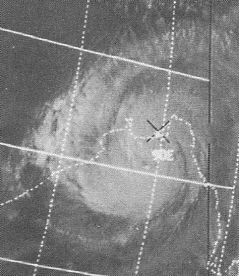
| 描述 |
English: This ITOS 1 weather satellite image of the November 12, 1970 Bay of Bengal Tropical Cyclone was taken at 0956 UTC |
| 日期 | |
| 來源 | Mariners Weather Log, January 1971, pg. 19 |
| 作者 | NOAA |
| Camera location | | View this and other nearby images on: OpenStreetMap |
|---|
協議
This image is in the public domain because it contains materials that originally came from the U.S. National Oceanic and Atmospheric Administration, taken or made as part of an employee's official duties.
|
Original upload log
| 日期/時間 | 尺寸 | 用戶 | 註解 |
|---|---|---|---|
| 2013年3月24號, 00:59:03 | 342 × 394 (152776 bytes) | Thegreatdr (傾偈 · 貢獻) | User created page with UploadWizard |
檔案歷史
撳個日期/時間去睇響嗰個時間出現過嘅檔案。
| 日期/時間 | 縮圖 | 尺寸 | 用戶 | 註解 | |
|---|---|---|---|---|---|
| 現時 | 2016年4月23號 (六) 17:40 | | 342 × 394(150 KB) | BMacZero | remove noise |
| 2014年8月23號 (六) 23:04 |  | 342 × 394(132 KB) | GifTagger | Bot: Converting file to superior PNG file. (Source: BayofBengalTCNov1219700956UTCITOS1.gif). This GIF was problematic due to non-greyscale color table. |
檔案用途
以下嘅1版用到呢個檔:
全域檔案使用情況
下面嘅維基都用緊呢個檔案:
- ar.wikipedia.org嘅使用情況
- bn.wikipedia.org嘅使用情況
- ca.wikipedia.org嘅使用情況
- cs.wikipedia.org嘅使用情況
- el.wikipedia.org嘅使用情況
- en.wikipedia.org嘅使用情況
- es.wikipedia.org嘅使用情況
- eu.wikipedia.org嘅使用情況
- fa.wikipedia.org嘅使用情況
- fi.wikipedia.org嘅使用情況
- fr.wikipedia.org嘅使用情況
- ga.wikipedia.org嘅使用情況
- he.wikipedia.org嘅使用情況
- hr.wikipedia.org嘅使用情況
- ml.wikipedia.org嘅使用情況
- my.wikipedia.org嘅使用情況
- oc.wikipedia.org嘅使用情況
- pt.wikipedia.org嘅使用情況
- ro.wikipedia.org嘅使用情況
- tr.wikipedia.org嘅使用情況
- ur.wikipedia.org嘅使用情況
- vi.wikipedia.org嘅使用情況
- www.wikidata.org嘅使用情況
- zh.wikipedia.org嘅使用情況