File:China, 610.svg

呢個「SVG」檔案嘅呢個「PNG」預覽嘅大細:705 × 599 像素。 第啲解像度:282 × 240 像素|565 × 480 像素|904 × 768 像素|1,205 × 1,024 像素|2,409 × 2,048 像素|1,000 × 850 像素。
原本檔案 (SVG檔案,表面大細: 1,000 × 850 像素,檔案大細:211 KB)
摘要
| 描述 |
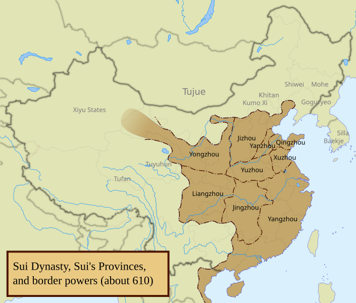
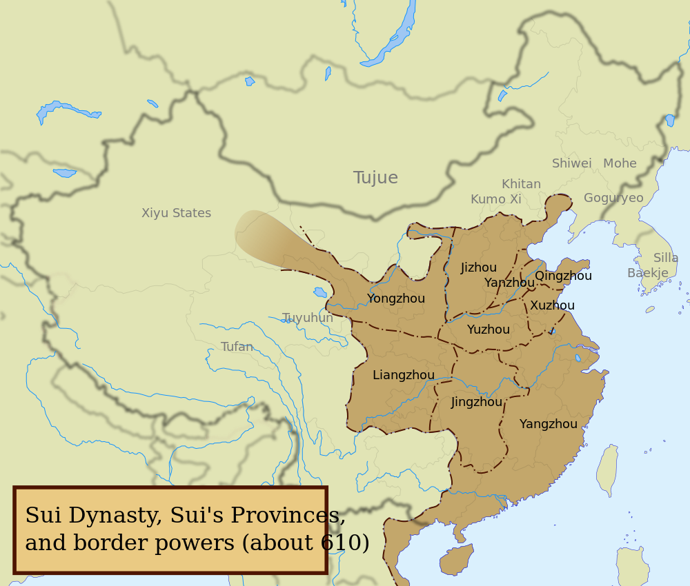
English: The Sui dynasty territory and political divisions, according to the CHC. NB: The Western area was not depict by my source, accordingly, this area is show by a blur area. |
| 日期 | see upload date |
| 來源 |
Image:China blank map.svg, Cambridge History of China, vol.3, map about Sui dynasty's divisions (see table of content). Current days countries and provinces borders are still vissible (in very soft) for comparaison.
|
| 作者 | Yug |
| Other versions |
[]
|


協議
我,呢份作品嘅作者,決定用以下許可發佈呢件作品:
呢個檔案用共享創意 姓名標示-非商業性-相同方式分享3.0 未本地化版本條款授權。
- 你可以:
- 去分享 – 複製、發佈同傳播呢個作品
- 再改 – 創作演繹作品
- 要遵照下面嘅條件:
- 署名 – 你一定要畀合適嘅表彰、畀返指向呢個授權條款嘅連結,同埋寫明有無改過嚟。你可以用任何合理方式去做,但唔可以用任何方式暗示授權人認可咗你或者你嘅使用方式。
- 相同方式分享 – 如果你用任何方式改過呢個作品,你必須要用返原本或者相似嘅條款發佈。
檔案歷史
撳個日期/時間去睇響嗰個時間出現過嘅檔案。
| 日期/時間 | 縮圖 | 尺寸 | 用戶 | 註解 | |
|---|---|---|---|---|---|
| 現時 | 2020年8月22號 (六) 12:28 | | 1,000 × 850(211 KB) | Friend505 | Corrected typo "Kithan" to "Khitan" |
| 2008年5月29號 (四) 16:23 |  | 1,000 × 850(217 KB) | Yug | correction of small typo mistake + addition of Provinces' names | |
| 2008年5月29號 (四) 16:19 |  | 1,000 × 850(217 KB) | Yug | ||
| 2008年5月29號 (四) 15:39 |  | 1,000 × 850(211 KB) | Yug | ||
| 2008年5月29號 (四) 15:10 |  | 1,000 × 850(210 KB) | Yug | ||
| 2008年5月29號 (四) 15:07 |  | 1,000 × 850(211 KB) | Yug | == Summary == {{Information |Description={{en|1=The Tang dynasty territory and political divisions, according to the CHC.<br />NB: The Western area was not depict by my source, accordingly, this area is show by a blur area.}} |Source=[[:Image:China blank |
檔案用途
無嘢連來呢份檔案。
全域檔案使用情況
下面嘅維基都用緊呢個檔案:
- ar.wikipedia.org嘅使用情況
- ast.wikipedia.org嘅使用情況
- ba.wikipedia.org嘅使用情況
- be.wikipedia.org嘅使用情況
- bg.wikipedia.org嘅使用情況
- bn.wikipedia.org嘅使用情況
- ca.wikipedia.org嘅使用情況
- cs.wikipedia.org嘅使用情況
- da.wikipedia.org嘅使用情況
- de.wikipedia.org嘅使用情況
- en.wikipedia.org嘅使用情況
- es.wikipedia.org嘅使用情況
- fr.wikipedia.org嘅使用情況
- gan.wikipedia.org嘅使用情況
- gl.wikipedia.org嘅使用情況
- he.wikipedia.org嘅使用情況
- hy.wikipedia.org嘅使用情況
- km.wikipedia.org嘅使用情況
- ko.wikipedia.org嘅使用情況
- ku.wikipedia.org嘅使用情況
- lt.wikipedia.org嘅使用情況
- lv.wikipedia.org嘅使用情況
- nn.wikipedia.org嘅使用情況
- no.wikipedia.org嘅使用情況
- ru.wikipedia.org嘅使用情況
- sk.wikipedia.org嘅使用情況
- tg.wikipedia.org嘅使用情況
- tt.wikipedia.org嘅使用情況
- www.wikidata.org嘅使用情況
- zh.wikipedia.org嘅使用情況