File:China India eastern border 88.jpg

預覽大細:483 × 600 像素。 第啲解像度:193 × 240 像素|387 × 480 像素|1,019 × 1,265 像素。
原本檔案 (1,019 × 1,265 像素,檔案大細:297 KB ,MIME類型:image/jpeg)
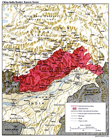
| 描述 | China India eastern border depicting disputed areas in this sector including NEFA. | |||
| 日期 | ||||
| 來源 | http://www.lib.utexas.edu/maps/middle_east_and_asia/china_india_e_border_88.jpg | |||
| 作者 | Central Intelligence Agency | |||
| 許可 (重用呢個檔案) |
|
|||
| Other versions |
 |

| Annotations | This image is annotated: View the annotations at Commons |
檔案歷史
撳個日期/時間去睇響嗰個時間出現過嘅檔案。
| 日期/時間 | 縮圖 | 尺寸 | 用戶 | 註解 | |
|---|---|---|---|---|---|
| 現時 | 2007年4月2號 (一) 04:59 | | 1,019 × 1,265(297 KB) | Yuje | China India eastern border depicting disputed areas in this sector including NEFA. Taken from [http://www.lib.utexas.edu/maps/middle_east_and_asia/china_indiae_border_88.jpg] |
檔案用途
以下嘅1版用到呢個檔:
全域檔案使用情況
下面嘅維基都用緊呢個檔案:
- as.wikipedia.org嘅使用情況
- bn.wikipedia.org嘅使用情況
- cs.wikipedia.org嘅使用情況
- de.wikipedia.org嘅使用情況
- en.wikipedia.org嘅使用情況
- es.wikipedia.org嘅使用情況
- fa.wikipedia.org嘅使用情況
- fr.wikipedia.org嘅使用情況
- gu.wikipedia.org嘅使用情況
- he.wikipedia.org嘅使用情況
- hi.wikipedia.org嘅使用情況
- hr.wikipedia.org嘅使用情況
- hu.wikipedia.org嘅使用情況
- id.wikipedia.org嘅使用情況
- it.wikipedia.org嘅使用情況
- ja.wikipedia.org嘅使用情況
- kn.wikipedia.org嘅使用情況
- ko.wikipedia.org嘅使用情況
- ky.wikipedia.org嘅使用情況
- lt.wikipedia.org嘅使用情況
- ms.wikipedia.org嘅使用情況
- ne.wikipedia.org嘅使用情況
- nl.wikipedia.org嘅使用情況
- pa.wikipedia.org嘅使用情況
- pl.wikipedia.org嘅使用情況
- pnb.wikipedia.org嘅使用情況
- pt.wikipedia.org嘅使用情況
睇呢個檔案嘅更多全域使用情況。