File:China prefectural-level divisions and administrative divisions (PRoC claim).png

原本檔案 (6,246 × 4,937 像素,檔案大細:987 KB ,MIME類型:image/png)


|
The boundaries on this map show the de facto situation. This is just one of several different views on the subject (see COM:NPOV). |

|
This image is expected to always be the most recent one. Feel free to update it when needed.
|

|
This file may be updated to reflect new information. If you wish to use a specific version of the file without new updates being mirrored, please upload the required version as a separate file. |
摘要
| Description |
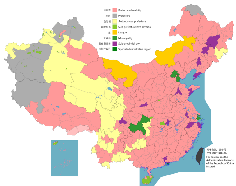
English: Map of China, shows provinces, prefecture-level divisions, etc.
日本語: 中国の地図、州、県レベルの区分などを示しています。
Русский: Карта Китая, показывает провинции, подразделения на уровне префектур и т. Д.
Монгол: Хятад улсын газрын зураг, мужууд, мужийн түвшний хэлтэс гэх мэтийг харуулсан.
中文(简体):中华人民共和国地图,显示省、地级区划等。(包含未实际控制之疆域)
中文(繁體):中華人民共和國地圖,顯示省、地級區劃等。 (包含未實際控制之疆域) |
||
| Map legend |
English:
Prefecture-level city
Prefecture
Autonomous prefecture
Sub prefecture-level division
League
Municipality
Sub-provincial city
Special administrative region 图例: 中文(简体):
地级市
地区
自治州
副地级市
盟
直辖市
副省级市
特别行政区 圖例: 中文(繁體): 地級市
地區
自治州
副地級市
盟
直轄市
副省級市
特別行政區 |
||
| 日期 |
English: File uploaded: November 6, 2021
English: Original uploaded: September 12, 2011
Latest update: 07:09, 17 November 2023 中文(简体):原始上传时间2011年9月12日
中文(繁體):文件上传时间2021年11月6日
中文(繁體):原始上傳時間2011年9月12日 |
||
| 來源 |
English: Source appearances: 中文(简体):来源于: 中文(繁體):來源於:
[]
|
||
| Creator |
|
||
| 許可 (重用呢個檔案) |
English: Map of China, administrative divisions: 中文(简体):中国地图,行政区划 中文(繁體):中國地圖,行政區劃 我,呢份作品嘅作者,決定用以下許可發佈呢件作品:
|
||
| Geotemporal data | |||
| Date depicted | as of February 4, 2021 | ||
| Spatial reference system | Custom | ||
| Georeferencing | |||
| Other versions |
English: Other languages: 中文(简体):其他语言: 中文(繁體):其他語言:
[]
Derivative works on these files: |
||


.png)
_sl.png)
.png?uselang=yue)
協議
我,呢份作品嘅作者,決定用以下許可發佈呢件作品:
This file is licensed under the Creative Commons Attribution-Share Alike 4.0 International license.
- 你可以:
- 去分享 – 複製、發佈同傳播呢個作品
- 再改 – 創作演繹作品
- 要遵照下面嘅條件:
- 署名 – 你一定要畀合適嘅表彰、畀返指向呢個授權條款嘅連結,同埋寫明有無改過嚟。你可以用任何合理方式去做,但唔可以用任何方式暗示授權人認可咗你或者你嘅使用方式。
- 相同方式分享 – 如果你用任何方式改過呢個作品,你必須要用返原本或者相似嘅條款發佈。

|
This locator map image could be recreated using vector graphics as an SVG file. This has several advantages; see Commons:Media for cleanup for more information. If an SVG form of this image is already available, please upload it. After uploading an SVG, replace this template with {{vector version available|new image name.svg}}.
|
|
|
This map image could be recreated using vector graphics as an SVG file. This has several advantages; see Commons:Media for cleanup for more information. If an SVG form of this image is already available, please upload it. After uploading an SVG, replace this template with {{vector version available|new image name.svg}}.
|
| Annotations | This image is annotated: View the annotations at Commons |
.png)
檔案歷史
撳個日期/時間去睇響嗰個時間出現過嘅檔案。
.png&dir=prev)
.png&offset=20220128000854)
.png&offset=&limit=20)
.png&offset=&limit=50)
.png&offset=&limit=100)
.png&offset=&limit=250)
.png&offset=&limit=500)
| 日期/時間 | 縮圖 | 尺寸 | 用戶 | 註解 | |
|---|---|---|---|---|---|
| 現時 | 2023年8月11號 (五) 02:26 | | 6,246 × 4,937(987 KB) | Vikarna | 州→地区 & 副地级划分→副地级市 |
| 2023年8月1號 (二) 08:59 |  | 6,246 × 4,937(987 KB) | Maanshen | Add Baiyang county-level city | |
| 2022年12月1號 (四) 09:50 |  | 6,246 × 4,937(987 KB) | Maanshen | Re-added disputed borders from the third version and removed the nine-dash line to prevent future bans to maps | |
| 2022年11月23號 (三) 05:28 |  | 6,246 × 4,937(951 KB) | Vikarna | municipality 市政府→直辖市 | |
| 2022年11月23號 (三) 05:10 |  | 6,246 × 4,937(986 KB) | Vikarna | League 联盟→盟 | |
| 2022年8月2號 (二) 23:06 |  | 6,246 × 4,937(992 KB) | Maanshen | Update disputed/claimed borders, white with stroke is not claimed and filled in color is claimed | |
| 2022年4月20號 (三) 00:08 |  | 6,246 × 4,937(975 KB) | Maanshen | Fix borders between Ili's Kuytun, Huyanghe, and Karamay | |
| 2022年3月1號 (二) 03:51 |  | 6,246 × 4,937(975 KB) | Maanshen | Update Shanghai land reclamation | |
| 2022年1月28號 (五) 08:26 |  | 6,246 × 4,937(975 KB) | Maanshen | Fix Changchun-Siping border | |
| 2022年1月28號 (五) 00:08 |  | 6,246 × 4,937(975 KB) | Maanshen | Add parts of Tiemenguan |
檔案用途
以下嘅1版用到呢個檔:
全域檔案使用情況
下面嘅維基都用緊呢個檔案:
- ast.wikipedia.org嘅使用情況
- bg.wikipedia.org嘅使用情況
- cs.wikipedia.org嘅使用情況
- en.wikipedia.org嘅使用情況
- es.wikipedia.org嘅使用情況
- fa.wikipedia.org嘅使用情況
- fi.wikipedia.org嘅使用情況
- fr.wikipedia.org嘅使用情況
- hu.wiktionary.org嘅使用情況
- id.wikipedia.org嘅使用情況
- incubator.wikimedia.org嘅使用情況
- ja.wikipedia.org嘅使用情況
- pt.wikipedia.org嘅使用情況
- ru.wikipedia.org嘅使用情況
- sh.wikipedia.org嘅使用情況
- si.wikipedia.org嘅使用情況
- sv.wikipedia.org嘅使用情況
- th.wikipedia.org嘅使用情況
- tr.wikipedia.org嘅使用情況
- ur.wikipedia.org嘅使用情況
- vi.wikipedia.org嘅使用情況
- www.wikidata.org嘅使用情況
- wuu.wikipedia.org嘅使用情況
- zh.wikipedia.org嘅使用情況
睇呢個檔案嘅更多全域使用情況。
.png)
.png)