File:Cosmographia. - Norman B. Leventhal Map Center at the BPL.jpg

預覽大細:800 × 562 像素。 第啲解像度:320 × 225 像素|640 × 450 像素|1,024 × 719 像素|1,200 × 843 像素。
原本檔案 (1,200 × 843 像素,檔案大細:478 KB ,MIME類型:image/jpeg)
摘要
| Artist |
Lord Nicolas the German (Donnus Nicholas Germanus), cartographer Johann the Blockcutter of Armsheim (Johannes Schnitzer or Johannes de Armsheim), engraver |
| 作者 | |
| 描述 |
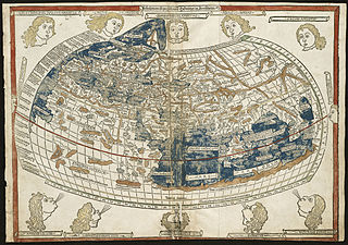
English: The world map from a 1482 edition of Nicolaus Germanus's emendations to Jacobus Angelus's 1406 Latin translation of Maximus Planudes's late-13th century rediscovered Greek manuscripts of Ptolemy's 2nd-century Geography.
BPL Call Number: G1005 .P7 1482 View at the Norman B. Leventhal Map Center Zoom into this map at maps.bpl.org. The classical Greek and Roman world view is known to us through the writings of Claudius Ptolemy, a 2nd century A.D. astronomer, mathematician, and geographer who lived in Alexandria, Egypt. Although his original manuscript no longer exists, various copies survived through the Middle Ages. With the advent of the printing press in the late-15th century, it was one the first geographical texts printed. The first printed editions of Geographia included a world map and 26 regional maps. These maps depicted the extent of the world as known to the ancient Greeks and Romans, which focused on the lands bordering the Mediterranean-- Europe, northern Africa, and western and southern Asia. Despite the disclosure of New World discoveries, such maps still had a strong influence on the Europeans' geographical concept of the world. Unfortunately for the early explorers, this world image underestimated the Earth's circumference and overestimated the breadth of the Eurasian land mass. While the first printed edition of Geographia that included maps was published in Bologna in 1477, the Ulm edition was the first printed north of the Alps and the first to include wood cut printed maps. New and updated versions of Geographia were printed until the mid-19th century. |
| 日期 | 1482年7月16號 |
| Source/Photographer | Norman Bleventhal Map Center on Flickr. |
| Other versions |
|


協議
Ĉi tiu dosiero estas disponebla laŭ la permesilo Krea Komunaĵo Atribuite 2.0 Ĝenerala.
- 你可以:
- 去分享 – 複製、發佈同傳播呢個作品
- 再改 – 創作演繹作品
- 要遵照下面嘅條件:
- 署名 – 你一定要畀合適嘅表彰、畀返指向呢個授權條款嘅連結,同埋寫明有無改過嚟。你可以用任何合理方式去做,但唔可以用任何方式暗示授權人認可咗你或者你嘅使用方式。
| This image was originally posted to Flickr by Norman B. Leventhal Map Center at the BPL at https://www.flickr.com/photos/24528911@N05/2709976847. It was reviewed on 2012年7月2號 by FlickreviewR and was confirmed to be licensed under the terms of the cc-by-2.0. |
檔案歷史
撳個日期/時間去睇響嗰個時間出現過嘅檔案。
| 日期/時間 | 縮圖 | 尺寸 | 用戶 | 註解 | |
|---|---|---|---|---|---|
| 現時 | 2012年7月2號 (一) 01:43 | | 1,200 × 843(478 KB) | Dzlinker | == {{int:filedesc}} == {{Information |Description=Zoom into [http://maps.bpl.org/id/M10001/ this map] at [http://maps.bpl.org maps.bpl.org]. '''Author:''' Ptolemy '''Publisher:''' Lienhart Holle '''Date:''' 16 July 1482. '''Call Number:''' G1005.1482... |
檔案用途
無嘢連來呢份檔案。
全域檔案使用情況
下面嘅維基都用緊呢個檔案:
- en.wikipedia.org嘅使用情況