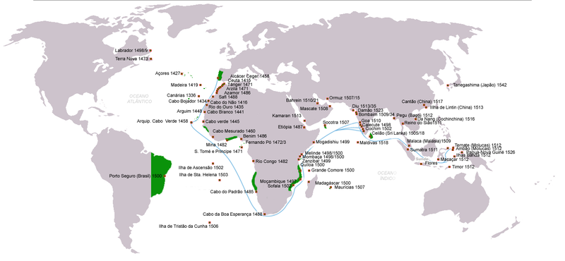
File:Descobrimentos e explorações portuguesesV2.png

預覽大細:800 × 370 像素。 第啲解像度:320 × 148 像素|640 × 296 像素|1,357 × 628 像素。
原本檔案 (1,357 × 628 像素,檔案大細:211 KB ,MIME類型:image/png)
檔案歷史
撳個日期/時間去睇響嗰個時間出現過嘅檔案。
| 日期/時間 | 縮圖 | 尺寸 | 用戶 | 註解 | |
|---|---|---|---|---|---|
| 現時 | 2011年6月13號 (一) 22:30 |  | 1,357 × 628(211 KB) | Uxbona | (Corrigida posição do reino do Sião/Tailândia; Acrescentar chegadas a Pegu, Sumatra e Cochinchina (Da Nang) ) |
| 2011年6月10號 (五) 22:44 |  | 1,357 × 628(211 KB) | Uxbona | actualização | |
| 2011年6月10號 (五) 22:41 |  | 1,357 × 628(211 KB) | Uxbona | actualização;correcção | |
| 2011年6月10號 (五) 13:37 |  | 1,357 × 628(211 KB) | Uxbona | Corrigida posição do reino do Sião/Tailândia; Acrescentar chegadas a Pegu, Sumatra e Cochinchina (Da Nang) | |
| 2010年4月11號 (日) 12:02 |  | 1,357 × 628(208 KB) | Uxbona | Completar dados, reduzir área de influência em África no reinado de D. João III (c.1536) | |
| 2009年6月10號 (三) 10:11 |  | 1,357 × 628(206 KB) | Uxbona | Datad corrigidas | |
| 2009年6月8號 (一) 21:42 |  | 1,357 × 628(206 KB) | Uxbona | acrescentar dados ( Reino do Sião) | |
| 2009年6月7號 (日) 18:23 |  | 1,357 × 628(205 KB) | Uxbona | Reverted to version as of 16:09, 7 June 2009 | |
| 2009年6月7號 (日) 18:21 |  | 1,357 × 628(204 KB) | Uxbona | English version | |
| 2009年6月7號 (日) 16:09 |  | 1,357 × 628(205 KB) | Uxbona | {{Information |Description=Portuguese discoveries and explorations, sea routes |Source=*File:Descobrimentos_e_explorações_portugueses.png |Date=2009-06-07 17:07 (UTC) |Author=*File:Descobrimentos_e_explorações_portugueses.png: *[[:File:Por |
檔案用途
以下嘅1版用到呢個檔:
全域檔案使用情況
下面嘅維基都用緊呢個檔案:
- ar.wikipedia.org嘅使用情況
- ast.wikipedia.org嘅使用情況
- bg.wikipedia.org嘅使用情況
- bn.wikipedia.org嘅使用情況
- ca.wikipedia.org嘅使用情況
- cs.wikipedia.org嘅使用情況
- en.wikipedia.org嘅使用情況
- es.wikipedia.org嘅使用情況
- fr.wikipedia.org嘅使用情況
- gl.wikipedia.org嘅使用情況
- it.wikipedia.org嘅使用情況
- ja.wikipedia.org嘅使用情況
- la.wikipedia.org嘅使用情況
- mwl.wikipedia.org嘅使用情況
- nl.wikipedia.org嘅使用情況
- pt.wikipedia.org嘅使用情況
- uk.wikipedia.org嘅使用情況
- vi.wikipedia.org嘅使用情況
- zh.wikipedia.org嘅使用情況
