File:EUROPE 1919-1929 POLITICAL 01.png
預覽大細:650 × 600 像素。 第啲解像度:260 × 240 像素|520 × 480 像素|827 × 763 像素。
原本檔案 (827 × 763 像素,檔案大細:114 KB ,MIME類型:image/png)
摘要
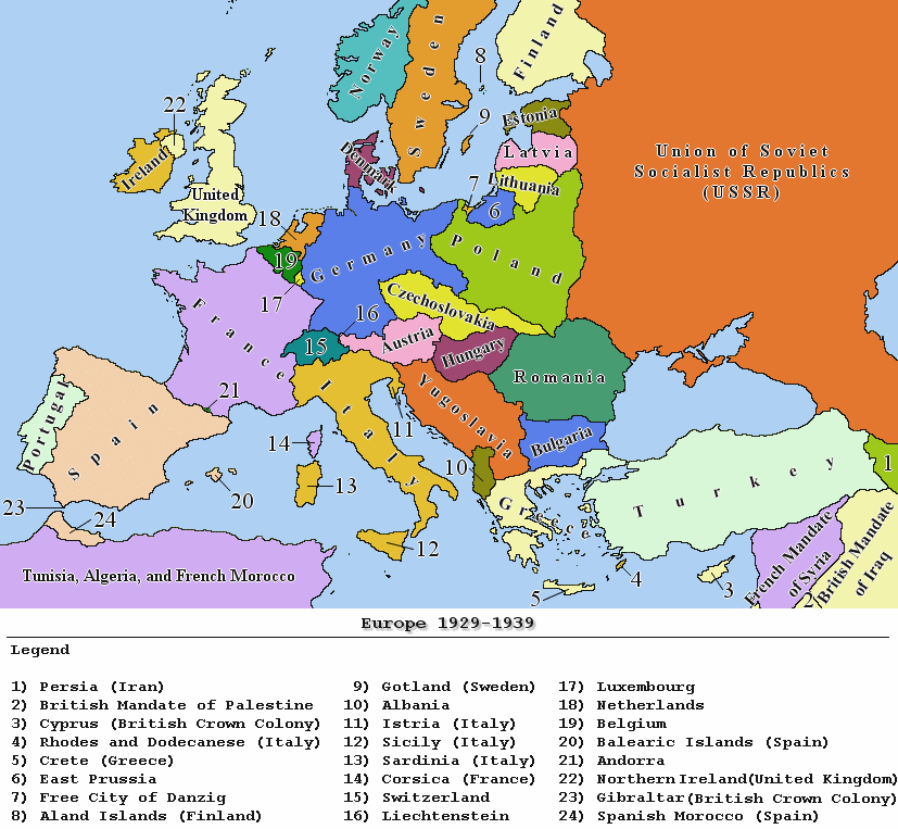
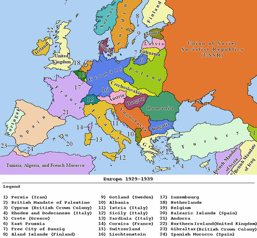
| 描述 | Political map of Europe between 1929 and 1939 |
| 日期 | |
| 來源 | 自己作品 |
| 作者 | Dros Catalin |
| 許可 (重用呢個檔案) |
GNU |
_en.png)
.png)
.jpg)

|
File:EUROPE 1929-1938 POLITICAL MAP.svg is a vector version of this file. It should be used in place of this PNG file when not inferior.
File:EUROPE 1919-1929 POLITICAL 01.png → File:EUROPE 1929-1938 POLITICAL MAP.svg
For more information, see Help:SVG. |
 |
協議
I, the copyright holder of this work, hereby publish it under the following licenses:

|
根據自由軟體基金會發佈嘅無固定段落、封面文字同封底文字GNU自由文件授權條款第1.2或打後嘅版本,你獲授權可以重製、散佈同埋修改爾份文件。授權條款嘅副本喺章節GNU自由文件授權條款。 |
| 呢個檔案用共享創意 姓名標示-非商業性-相同方式分享3.0 未本地化版本條款授權。 | ||
| ||
| This licensing tag was added to this file as part of the GFDL licensing update. |
This file is licensed under the Creative Commons Attribution-Share Alike 2.5 Generic, 2.0 Generic and 1.0 Generic license.
- 你可以:
- 去分享 – 複製、發佈同傳播呢個作品
- 再改 – 創作演繹作品
- 要遵照下面嘅條件:
- 署名 – 你一定要畀合適嘅表彰、畀返指向呢個授權條款嘅連結,同埋寫明有無改過嚟。你可以用任何合理方式去做,但唔可以用任何方式暗示授權人認可咗你或者你嘅使用方式。
- 相同方式分享 – 如果你用任何方式改過呢個作品,你必須要用返原本或者相似嘅條款發佈。
你可以揀你想用嘅牌照。
| Annotations | This image is annotated: View the annotations at Commons |
檔案歷史
撳個日期/時間去睇響嗰個時間出現過嘅檔案。
| 日期/時間 | 縮圖 | 尺寸 | 用戶 | 註解 | |
|---|---|---|---|---|---|
| 現時 | 2010年1月25號 (一) 21:19 | | 827 × 763(114 KB) | Ras67 | removed borders with PSP |
| 2009年4月11號 (六) 23:37 |  | 857 × 800(117 KB) | Hohum | Toned down bright colours. | |
| 2008年2月29號 (五) 07:53 |  | 857 × 800(96 KB) | Hoshie | fixed the legend | |
| 2006年12月27號 (三) 19:34 |  | 857 × 800(113 KB) | JanhumpoliK | {{Information |Description=Political map of Europe between the years 1929 and 1939 |Source=own work |Date=December 27, 2006 |Author=Jan Humpolík |Permission=GNU |other_versions=N/A }} |
檔案用途
無嘢連來呢份檔案。
全域檔案使用情況
下面嘅維基都用緊呢個檔案:
- ca.wikipedia.org嘅使用情況
- de.wikipedia.org嘅使用情況
- el.wikipedia.org嘅使用情況
- en.wikipedia.org嘅使用情況
- eo.wikipedia.org嘅使用情況
- eu.wikipedia.org嘅使用情況
- fi.wikipedia.org嘅使用情況
- fr.wikipedia.org嘅使用情況
- fy.wikipedia.org嘅使用情況
- gl.wikipedia.org嘅使用情況
- hi.wikipedia.org嘅使用情況
- hy.wikipedia.org嘅使用情況
- id.wikipedia.org嘅使用情況
- it.wikipedia.org嘅使用情況
- krc.wikipedia.org嘅使用情況
- lt.wikipedia.org嘅使用情況
- nn.wikipedia.org嘅使用情況
- ro.wikipedia.org嘅使用情況